

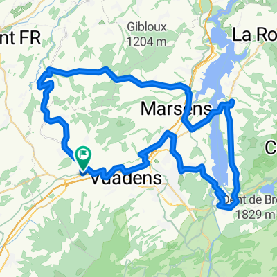
Tour de lac de Gruyère
A cycling route starting in Sâles, Canton of Fribourg, Switzerland.
Overview
About this route
- -:--
- Duration
- 65.1 km
- Distance
- 447 m
- Ascent
- 449 m
- Descent
- ---
- Avg. speed
- ---
- Max. altitude
Route quality
Waytypes & surfaces along the route
Waytypes
Busy road
22.5 km
(35 %)
Road
20.4 km
(31 %)
Surfaces
Paved
24.3 km
(37 %)
Unpaved
1.4 km
(2 %)
Asphalt
21 km
(32 %)
Paved (undefined)
3.3 km
(5 %)
Continue with Bikemap
Use, edit, or download this cycling route
You would like to ride Tour de lac de Gruyère or customize it for your own trip? Here is what you can do with this Bikemap route:
Free features
- Save this route as favorite or in collections
- Copy & plan your own version of this route
- Sync your route with Garmin or Wahoo
Premium features
Free trial for 3 days, or one-time payment. More about Bikemap Premium.
- Navigate this route on iOS & Android
- Export a GPX / KML file of this route
- Create your custom printout (try it for free)
- Download this route for offline navigation
Discover more Premium features.
Get Bikemap PremiumFrom our community
Other popular routes starting in Sâles
 Vaulruz - Vaulruz par le Chtelard - Corbière - Bulle
- Distance
- 50.4 km
- Ascent
- 692 m
- Descent
- 691 m
- Location
- Sâles, Canton of Fribourg, Switzerland
 Glâne fribourgeoise
- Distance
- 68.8 km
- Ascent
- 795 m
- Descent
- 794 m
- Location
- Sâles, Canton of Fribourg, Switzerland
 Tour du Lac de La Gruyère depuis Vaulruz
- Distance
- 53.6 km
- Ascent
- 448 m
- Descent
- 448 m
- Location
- Sâles, Canton of Fribourg, Switzerland
 Tour de lac de Gruyère
- Distance
- 65.1 km
- Ascent
- 447 m
- Descent
- 449 m
- Location
- Sâles, Canton of Fribourg, Switzerland
 Vaulruz - Vaulruz par Le Châtelard - Corbière-Bulle-les Colombettes
- Distance
- 50.9 km
- Ascent
- 697 m
- Descent
- 695 m
- Location
- Sâles, Canton of Fribourg, Switzerland
 Vaulruz-Châtel-Romont-Oron-Romanens
- Distance
- 71.9 km
- Ascent
- 947 m
- Descent
- 944 m
- Location
- Sâles, Canton of Fribourg, Switzerland
 Les Mosses 38, Sâles à Route du Centre-Sportif 7a, Sâles
- Distance
- 56.5 km
- Ascent
- 819 m
- Descent
- 821 m
- Location
- Sâles, Canton of Fribourg, Switzerland
 From Sâles to Romont (Fribourg)
- Distance
- 11.5 km
- Ascent
- 62 m
- Descent
- 242 m
- Location
- Sâles, Canton of Fribourg, Switzerland
Open it in the app