
0410第一次挑戰羅馬公路
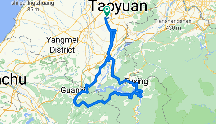
A cycling route starting in Taoyuan, Taiwan, Taiwan.
Overview
About this route
The mountain route is not suitable for beginners.
- -:--
- Duration
- 106.5 km
- Distance
- 2,193 m
- Ascent
- 2,083 m
- Descent
- ---
- Avg. speed
- 597 m
- Max. altitude
Route quality
Waytypes & surfaces along the route
Waytypes
Road
33 km
(31 %)
Access road
8.5 km
(8 %)
Surfaces
Paved
17 km
(16 %)
Asphalt
16 km
(15 %)
Paved (undefined)
1.1 km
(1 %)
Undefined
89.5 km
(84 %)
Route highlights
Points of interest along the route
Point of interest after 0 km
Point of interest after 104.2 km
Continue with Bikemap
Use, edit, or download this cycling route
You would like to ride 0410第一次挑戰羅馬公路 or customize it for your own trip? Here is what you can do with this Bikemap route:
Free features
- Save this route as favorite or in collections
- Copy & plan your own version of this route
- Split it into stages to create a multi-day tour
- Sync your route with Garmin or Wahoo
Premium features
Free trial for 3 days, or one-time payment. More about Bikemap Premium.
- Navigate this route on iOS & Android
- Export a GPX / KML file of this route
- Create your custom printout (try it for free)
- Download this route for offline navigation
Discover more Premium features.
Get Bikemap PremiumFrom our community
Other popular routes starting in Taoyuan
 0410第一次挑戰羅馬公路
- Distance
- 106.5 km
- Ascent
- 2,193 m
- Descent
- 2,083 m
- Location
- Taoyuan, Taiwan, Taiwan
 一日北橫
一日北橫- Distance
- 145.4 km
- Ascent
- 1,683 m
- Descent
- 1,783 m
- Location
- Taoyuan, Taiwan, Taiwan
 家樂福-大溪-羅馬公路-關西-龍潭
- Distance
- 91.7 km
- Ascent
- 1,055 m
- Descent
- 1,058 m
- Location
- Taoyuan, Taiwan, Taiwan
 虎頭山環保公園
- Distance
- 5.4 km
- Ascent
- 170 m
- Descent
- 40 m
- Location
- Taoyuan, Taiwan, Taiwan
 石門水庫環湖公路
- Distance
- 56.7 km
- Ascent
- 635 m
- Descent
- 629 m
- Location
- Taoyuan, Taiwan, Taiwan
 永安竹圍挑戰78KM
- Distance
- 78.1 km
- Ascent
- 190 m
- Descent
- 187 m
- Location
- Taoyuan, Taiwan, Taiwan
 桃園大溪三坑鐵馬道
- Distance
- 46.8 km
- Ascent
- 426 m
- Descent
- 426 m
- Location
- Taoyuan, Taiwan, Taiwan
 環台完整路線
- Distance
- 1,270.9 km
- Ascent
- 1,936 m
- Descent
- 1,936 m
- Location
- Taoyuan, Taiwan, Taiwan
Open it in the app