

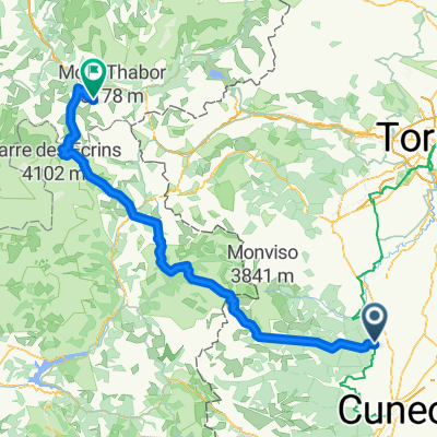
Col Bonnette Tour
A cycling route starting in Costigliole Saluzzo, Piedmont, Italy.
Overview
About this route
- -:--
- Duration
- 320.7 km
- Distance
- 6,571 m
- Ascent
- 6,580 m
- Descent
- ---
- Avg. speed
- ---
- Max. altitude

Route quality
Waytypes & surfaces along the route
Waytypes
Busy road
203 km
(63 %)
Quiet road
39.6 km
(12 %)
Surfaces
Paved
107.3 km
(33 %)
Unpaved
27.1 km
(8 %)
Asphalt
106.8 km
(33 %)
Gravel
19.8 km
(6 %)
Continue with Bikemap
Use, edit, or download this cycling route
You would like to ride Col Bonnette Tour or customize it for your own trip? Here is what you can do with this Bikemap route:
Free features
- Save this route as favorite or in collections
- Copy & plan your own version of this route
- Split it into stages to create a multi-day tour
- Sync your route with Garmin or Wahoo
Premium features
Free trial for 3 days, or one-time payment. More about Bikemap Premium.
- Navigate this route on iOS & Android
- Export a GPX / KML file of this route
- Create your custom printout (try it for free)
- Download this route for offline navigation
Discover more Premium features.
Get Bikemap PremiumFrom our community
Other popular routes starting in Costigliole Saluzzo
 SAMPEYRE DA CASTIGLIOLO DI SALUZZO
- Distance
- 101.8 km
- Ascent
- 1,877 m
- Descent
- 1,883 m
- Location
- Costigliole Saluzzo, Piedmont, Italy
 Col Dell'Agnello
- Distance
- 57.6 km
- Ascent
- 2,315 m
- Descent
- 25 m
- Location
- Costigliole Saluzzo, Piedmont, Italy
 1°luglio Valmala - strada dei cannoni - punta cavallo - colle del prete - colle gilba - monbracco
- Distance
- 158.3 km
- Ascent
- 4,634 m
- Descent
- 4,777 m
- Location
- Costigliole Saluzzo, Piedmont, Italy
 COSTIGLIOLE SALUZZO, SAMPEYRE DA STROPPO, COLLE DELL'AGNELLO, COSTIGLIOLE
- Distance
- 163.5 km
- Ascent
- 3,543 m
- Descent
- 3,551 m
- Location
- Costigliole Saluzzo, Piedmont, Italy
 Costigliole Saluzzo-Valmeiner Station
- Distance
- 189.6 km
- Ascent
- 5,089 m
- Descent
- 3,682 m
- Location
- Costigliole Saluzzo, Piedmont, Italy
 TREm
TREm- Distance
- 262.6 km
- Ascent
- 6,073 m
- Descent
- 6,001 m
- Location
- Costigliole Saluzzo, Piedmont, Italy
 Costigliole - colletta rossana
- Distance
- 16.2 km
- Ascent
- 545 m
- Descent
- 388 m
- Location
- Costigliole Saluzzo, Piedmont, Italy
 Costigliole Tour santuario Valmala
- Distance
- 46.6 km
- Ascent
- 995 m
- Descent
- 992 m
- Location
- Costigliole Saluzzo, Piedmont, Italy
Open it in the app