

Pto Las Palomas Junio 2018
A cycling route starting in Zahara, Andalusia, Spain.
Overview
About this route
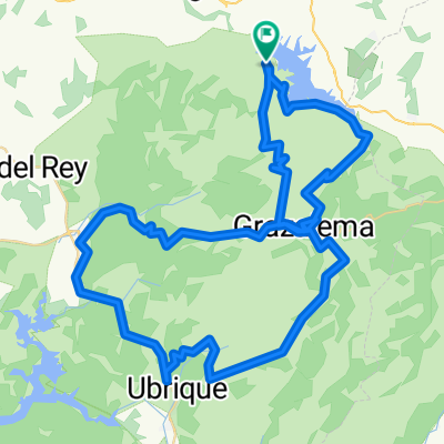
We start from Zahara de la Sierra, specifically from the CA9104 road that goes up to the puerto de las Palomas and descends to the junction with A372 Benamahoma/Grazalema. There we turn right and climb the Boyarín (Puerto El Boyar) and descend via the Sendero de los Charcones, until we come back to Ctra A372. We descend to the Plaza Principal of Grazalema, where we refuel. We leave Grazalema via A372 heading towards Villaluenga and just exiting we turn left onto Ctra CA9123 towards Gaidovar and Algodonales. Once past the Ermita Ntra Sra del Rosario and about 2 km further, at a very tight 180º right curve, we take a left onto the Cañada Real de Los Corderos that borders the entire mountainous mass of Monte Prieto, where it will offer us beautiful views of the Zahara reservoir a bit further on. We reach Ctra A2300 where we turn left towards Zahara de la Sierra. About 500 meters later, right at the crossing that leads to the Playita de Arroyomolinos, we turn right where we take a path that skirts the reservoir and the road, with magnificent views. We exit again onto Ctra A2300 and turn left, arriving in Zahara and at the same starting point.
- -:--
- Duration
- 39.3 km
- Distance
- 1,060 m
- Ascent
- 1,063 m
- Descent
- ---
- Avg. speed
- ---
- Max. altitude
Route quality
Waytypes & surfaces along the route
Waytypes
Road
20.9 km
(53 %)
Track
8.3 km
(21 %)
Surfaces
Paved
20.1 km
(51 %)
Unpaved
2 km
(5 %)
Asphalt
20.1 km
(51 %)
Pebblestone
2 km
(5 %)
Undefined
17.3 km
(44 %)
Route highlights
Points of interest along the route
Point of interest after 0 km
Inicio de Ruta
Point of interest after 20 km
Avituallamiento
Continue with Bikemap
Use, edit, or download this cycling route
You would like to ride Pto Las Palomas Junio 2018 or customize it for your own trip? Here is what you can do with this Bikemap route:
Free features
- Save this route as favorite or in collections
- Copy & plan your own version of this route
- Sync your route with Garmin or Wahoo
Premium features
Free trial for 3 days, or one-time payment. More about Bikemap Premium.
- Navigate this route on iOS & Android
- Export a GPX / KML file of this route
- Create your custom printout (try it for free)
- Download this route for offline navigation
Discover more Premium features.
Get Bikemap PremiumFrom our community
Other popular routes starting in Zahara
 Zahara-Las Palomas-Grazalema-Arroyomolinos-Zahara
- Distance
- 35.6 km
- Ascent
- 1,487 m
- Descent
- 1,594 m
- Location
- Zahara, Andalusia, Spain
 To via verde from Zahara
- Distance
- 67.1 km
- Ascent
- 834 m
- Descent
- 834 m
- Location
- Zahara, Andalusia, Spain
 Las Palomas - El Boyar - variante II - www.zonaciclista.com
- Distance
- 89.6 km
- Ascent
- 1,764 m
- Descent
- 1,788 m
- Location
- Zahara, Andalusia, Spain
 GRAZALEMA 2017 UNICA
- Distance
- 89.2 km
- Ascent
- 2,074 m
- Descent
- 2,058 m
- Location
- Zahara, Andalusia, Spain
 Grazalema 2018
- Distance
- 85.4 km
- Ascent
- 2,106 m
- Descent
- 2,009 m
- Location
- Zahara, Andalusia, Spain
 Some of the way up to Grazalema
- Distance
- 9.6 km
- Ascent
- 819 m
- Descent
- 174 m
- Location
- Zahara, Andalusia, Spain
 zahara-67km
- Distance
- 67.5 km
- Ascent
- 1,274 m
- Descent
- 1,264 m
- Location
- Zahara, Andalusia, Spain
 Las Palomas
- Distance
- 90 km
- Ascent
- 1,984 m
- Descent
- 1,976 m
- Location
- Zahara, Andalusia, Spain
Open it in the app