
Rangiswanger Alpe / Hörnerbahn / Schwabenhaus
A cycling route starting in Sonthofen, Bavaria, Germany.
Overview
About this route
Vor und nach der Rangiswanger Alpe müssen die weniger geübten schieben. Weiter über den Wanderweg zur Hörnerbahn. Abfahrt am besten über das Bolgental, da die Abfahrt zur Hörnerbahn-Talstation über die Schotter/Asphaltstraße ziemlich steil ist und die Bremsen ordentlich beansprucht!
- -:--
- Duration
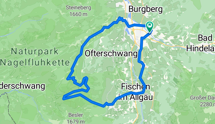
- 41.1 km
- Distance
- 988 m
- Ascent
- 988 m
- Descent
- ---
- Avg. speed
- ---
- Avg. speed

Continue with Bikemap
Use, edit, or download this cycling route
You would like to ride Rangiswanger Alpe / Hörnerbahn / Schwabenhaus or customize it for your own trip? Here is what you can do with this Bikemap route:
Free features
- Save this route as favorite or in collections
- Copy & plan your own version of this route
- Sync your route with Garmin or Wahoo
Premium features
Free trial for 3 days, or one-time payment. More about Bikemap Premium.
- Navigate this route on iOS & Android
- Export a GPX / KML file of this route
- Create your custom printout (try it for free)
- Download this route for offline navigation
Discover more Premium features.
Get Bikemap PremiumFrom our community
Other popular routes starting in Sonthofen
 Sonthofen Schrofenpass Lechtal
- Distance
- 58.2 km
- Ascent
- 971 m
- Descent
- 650 m
- Location
- Sonthofen, Bavaria, Germany
 Sonthofer und Altstädter Hof
- Distance
- 21.6 km
- Ascent
- 698 m
- Descent
- 696 m
- Location
- Sonthofen, Bavaria, Germany
 Bergkäs Runde Oberallgäu - Bregenzer Wald
- Distance
- 71.3 km
- Ascent
- 987 m
- Descent
- 989 m
- Location
- Sonthofen, Bavaria, Germany
 einfache Talrunde (mit Altst.-Hof)
- Distance
- 33.7 km
- Ascent
- 824 m
- Descent
- 821 m
- Location
- Sonthofen, Bavaria, Germany
 Zweite Runde 14.05.2025 16:43:29
- Distance
- 15.5 km
- Ascent
- 101 m
- Descent
- 100 m
- Location
- Sonthofen, Bavaria, Germany
 12.05.2025 15:18:28
- Distance
- 19 km
- Ascent
- 110 m
- Descent
- 109 m
- Location
- Sonthofen, Bavaria, Germany
 Allgäu-Oberjoch-Tannheimer Tal
- Distance
- 87.4 km
- Ascent
- 953 m
- Descent
- 953 m
- Location
- Sonthofen, Bavaria, Germany
 Sonthofen-Oberstdorf
- Distance
- 32 km
- Ascent
- 76 m
- Descent
- 76 m
- Location
- Sonthofen, Bavaria, Germany
Open it in the app