

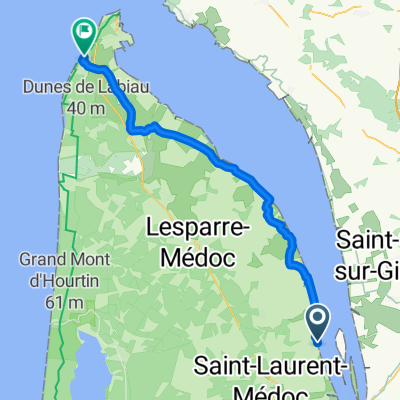
Tour de Gironde Stage 2: Paullac - La porge
A cycling route starting in Pauillac, Nouvelle-Aquitaine, France.
Overview
About this route
Tour de Gironde Stage 2: Paullac - La porge
- -:--
- Duration
- 212.3 km
- Distance
- 208 m
- Ascent
- 194 m
- Descent
- ---
- Avg. speed
- ---
- Max. altitude

Route quality
Waytypes & surfaces along the route
Waytypes
Busy road
102 km
(48 %)
Cycleway
41.9 km
(20 %)
Surfaces
Paved
114.7 km
(54 %)
Unpaved
1.5 km
(<1 %)
Asphalt
113.9 km
(54 %)
Unpaved (undefined)
1.3 km
(<1 %)
Continue with Bikemap
Use, edit, or download this cycling route
You would like to ride Tour de Gironde Stage 2: Paullac - La porge or customize it for your own trip? Here is what you can do with this Bikemap route:
Free features
- Save this route as favorite or in collections
- Copy & plan your own version of this route
- Split it into stages to create a multi-day tour
- Sync your route with Garmin or Wahoo
Premium features
Free trial for 3 days, or one-time payment. More about Bikemap Premium.
- Navigate this route on iOS & Android
- Export a GPX / KML file of this route
- Create your custom printout (try it for free)
- Download this route for offline navigation
Discover more Premium features.
Get Bikemap PremiumFrom our community
Other popular routes starting in Pauillac
 Pauillac nach Soulac sur Mer
- Distance
- 56.3 km
- Ascent
- 64 m
- Descent
- 62 m
- Location
- Pauillac, Nouvelle-Aquitaine, France
 Tour de Gironde Stage 2: Paullac - La porge
- Distance
- 212.3 km
- Ascent
- 208 m
- Descent
- 194 m
- Location
- Pauillac, Nouvelle-Aquitaine, France
 F202
F202- Distance
- 38.2 km
- Ascent
- 63 m
- Descent
- 67 m
- Location
- Pauillac, Nouvelle-Aquitaine, France
 Marathon du Medoc (les chateaux)
- Distance
- 43 km
- Ascent
- 116 m
- Descent
- 119 m
- Location
- Pauillac, Nouvelle-Aquitaine, France
 Marathon du Medoc (velo)
- Distance
- 42.1 km
- Ascent
- 110 m
- Descent
- 110 m
- Location
- Pauillac, Nouvelle-Aquitaine, France
 86km margaux 2
- Distance
- 85.8 km
- Ascent
- 120 m
- Descent
- 121 m
- Location
- Pauillac, Nouvelle-Aquitaine, France
 Daubos to Libourne
- Distance
- 72.4 km
- Ascent
- 211 m
- Descent
- 222 m
- Location
- Pauillac, Nouvelle-Aquitaine, France
 Medoc-Marathon
- Distance
- 34 km
- Ascent
- 75 m
- Descent
- 80 m
- Location
- Pauillac, Nouvelle-Aquitaine, France
Open it in the app