

Profi-Tour des Rad-Team-Rathenow
A cycling route starting in Rathenow, Brandenburg, Germany.
Overview
About this route
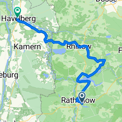
Von Rathenow entlang der Landstraße über Bamme nach Gräningen. Von dort führt der Abzweig nach Nennhausen. Weiter geht es über Damme, Liepe und Möthlow. Hier biegt die Streck in nördlicher Richtung nach Retzow ab. Kurz vor Ende der Ortslage biegt der Weg nach Westen in Richtung Pessin ab. Von dort folgt der Weg dem Havelland-Radweg über Senzke und Kriele nach Kotzen. Über das Hohe Rott geht es zurück nach Nennhausen und durch Gräningen und Bamme zurück nach Rathenow
- -:--
- Duration
- 63.3 km
- Distance
- 168 m
- Ascent
- 166 m
- Descent
- ---
- Avg. speed
- ---
- Max. altitude

Route quality
Waytypes & surfaces along the route
Waytypes
Busy road
39.9 km
(63 %)
Track
8.2 km
(13 %)
Surfaces
Paved
60.1 km
(95 %)
Unpaved
0 km
(<1 %)
Asphalt
58.7 km
(93 %)
Paving stones
1.1 km
(2 %)
Route highlights
Points of interest along the route
Photo after 5 km
Brücke über das Rodewaldsche Luch
Photo after 11.9 km
Hier kann man den Gräninger See erahnen. Er verlandet sehr stark.
Photo after 22.2 km
Slawenburg und Alte Brennerei
Photo after 29.1 km
Ehemaliges Herrenhaus Retzow
Photo after 31.2 km
Dorfkirche und Herrenhaus Pessin
Photo after 33.2 km
Blick über das Havelländische Luch
Photo after 36.9 km
Herrenhaus Senzke, Dorfkirche Senzke mit Gruft und Fintelmannhaus
Photo after 42.1 km
Papierwerkstatt
Point of interest after 46.6 km
Steiler Anstieg auf das Hohe Rott
Photo after 48.6 km
Blick zum Schloss Nennhausen
Photo after 56.5 km
Blick auf die Ortslage Bamme und zurück auf den Markgrafenberg
Continue with Bikemap
Use, edit, or download this cycling route
You would like to ride Profi-Tour des Rad-Team-Rathenow or customize it for your own trip? Here is what you can do with this Bikemap route:
Free features
- Save this route as favorite or in collections
- Copy & plan your own version of this route
- Sync your route with Garmin or Wahoo
Premium features
Free trial for 3 days, or one-time payment. More about Bikemap Premium.
- Navigate this route on iOS & Android
- Export a GPX / KML file of this route
- Create your custom printout (try it for free)
- Download this route for offline navigation
Discover more Premium features.
Get Bikemap PremiumFrom our community
Other popular routes starting in Rathenow
 RTF Zwi. Havel und Elbe 110
- Distance
- 109.3 km
- Ascent
- 233 m
- Descent
- 239 m
- Location
- Rathenow, Brandenburg, Germany
 Dörfer, Felder, Wälder und die Havel
- Distance
- 31 km
- Ascent
- 78 m
- Descent
- 80 m
- Location
- Rathenow, Brandenburg, Germany
 Tour Brandenburg 1
- Distance
- 61.6 km
- Ascent
- 53 m
- Descent
- 54 m
- Location
- Rathenow, Brandenburg, Germany
 Abradeln 2017
- Distance
- 62 km
- Ascent
- 118 m
- Descent
- 118 m
- Location
- Rathenow, Brandenburg, Germany
 Rathenow-Semlin-Hohennauen-Semlin-RN
- Distance
- 33.5 km
- Ascent
- 27 m
- Descent
- 24 m
- Location
- Rathenow, Brandenburg, Germany
 RTF 110 Quer durchs Havelland
- Distance
- 118.2 km
- Ascent
- 169 m
- Descent
- 168 m
- Location
- Rathenow, Brandenburg, Germany
 RTF Quer durch`s Havelland
- Distance
- 146.3 km
- Ascent
- 520 m
- Descent
- 517 m
- Location
- Rathenow, Brandenburg, Germany
 Rathenow, südliche Havel (groß)
- Distance
- 56.9 km
- Ascent
- 135 m
- Descent
- 136 m
- Location
- Rathenow, Brandenburg, Germany
Open it in the app