

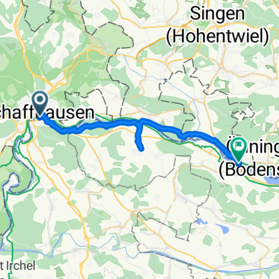
Flöro #1
A cycling route starting in Schaffhausen, Canton of Schaffhausen, Switzerland.
Overview
About this route
Längenberg _Hagen-Zegli
- -:--
- Duration
- 34.7 km
- Distance
- 797 m
- Ascent
- 800 m
- Descent
- ---
- Avg. speed
- ---
- Max. altitude

Continue with Bikemap
Use, edit, or download this cycling route
You would like to ride Flöro #1 or customize it for your own trip? Here is what you can do with this Bikemap route:
Free features
- Save this route as favorite or in collections
- Copy & plan your own version of this route
- Sync your route with Garmin or Wahoo
Premium features
Free trial for 3 days, or one-time payment. More about Bikemap Premium.
- Navigate this route on iOS & Android
- Export a GPX / KML file of this route
- Create your custom printout (try it for free)
- Download this route for offline navigation
Discover more Premium features.
Get Bikemap PremiumFrom our community
Other popular routes starting in Schaffhausen
 - Siblingen
- Distance
- 19.1 km
- Ascent
- 483 m
- Descent
- 440 m
- Location
- Schaffhausen, Canton of Schaffhausen, Switzerland
 1. August-Runde
- Distance
- 59.3 km
- Ascent
- 328 m
- Descent
- 335 m
- Location
- Schaffhausen, Canton of Schaffhausen, Switzerland
 Schaffhausen - Eschenz
- Distance
- 24.9 km
- Ascent
- 285 m
- Descent
- 278 m
- Location
- Schaffhausen, Canton of Schaffhausen, Switzerland
 Steigstrasse, Schaffhausen nach Bahnhofstraße, Villingen-Schwenningen
- Distance
- 51.3 km
- Ascent
- 897 m
- Descent
- 643 m
- Location
- Schaffhausen, Canton of Schaffhausen, Switzerland
 Bahnhofstrasse, Schaffhausen to Nohlstrasse, Neuhausen am Rheinfall
- Distance
- 4.5 km
- Ascent
- 83 m
- Descent
- 99 m
- Location
- Schaffhausen, Canton of Schaffhausen, Switzerland
 Randenstrasse, Schaffhausen to Viarhenana, Neuhausen am Rheinfall
- Distance
- 3.9 km
- Ascent
- 16 m
- Descent
- 111 m
- Location
- Schaffhausen, Canton of Schaffhausen, Switzerland
 steckborn huttwielersee Husumer See schaffhausen
- Distance
- 70.9 km
- Ascent
- 567 m
- Descent
- 646 m
- Location
- Schaffhausen, Canton of Schaffhausen, Switzerland
 Wiesenweg nach Heinrich-Ernst-Kromer-Straße
- Distance
- 73 km
- Ascent
- 2,208 m
- Descent
- 1,747 m
- Location
- Schaffhausen, Canton of Schaffhausen, Switzerland
Open it in the app