

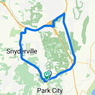
Deer valley loop
A cycling route starting in Park City, Utah, United States.
Overview
About this route
- -:--
- Duration
- 82.1 km
- Distance
- 1,686 m
- Ascent
- 1,697 m
- Descent
- ---
- Avg. speed
- ---
- Max. altitude

Route quality
Waytypes & surfaces along the route
Waytypes
Road
37 km
(45 %)
Quiet road
5.7 km
(7 %)
Surfaces
Paved
69 km
(84 %)
Unpaved
1.6 km
(2 %)
Asphalt
67.3 km
(82 %)
Paved (undefined)
1.6 km
(2 %)
Continue with Bikemap
Use, edit, or download this cycling route
You would like to ride Deer valley loop or customize it for your own trip? Here is what you can do with this Bikemap route:
Free features
- Save this route as favorite or in collections
- Copy & plan your own version of this route
- Split it into stages to create a multi-day tour
- Sync your route with Garmin or Wahoo
Premium features
Free trial for 3 days, or one-time payment. More about Bikemap Premium.
- Navigate this route on iOS & Android
- Export a GPX / KML file of this route
- Create your custom printout (try it for free)
- Download this route for offline navigation
Discover more Premium features.
Get Bikemap PremiumFrom our community
Other popular routes starting in Park City
 SWCC Day 1
- Distance
- 97.6 km
- Ascent
- 849 m
- Descent
- 849 m
- Location
- Park City, Utah, United States
 Park City to Soapstone Mt. (Utah 2024)
- Distance
- 100.6 km
- Ascent
- 1,310 m
- Descent
- 1,310 m
- Location
- Park City, Utah, United States
 Day 13 Park City to Evanston
- Distance
- 97.8 km
- Ascent
- 466 m
- Descent
- 461 m
- Location
- Park City, Utah, United States
 Union Pacific Rail Trail, Park City to Union Pacific Rail Trail, Park City
- Distance
- 28.8 km
- Ascent
- 197 m
- Descent
- 197 m
- Location
- Park City, Utah, United States
 Trailforks Route Plan - Trailforks Route Plan
- Distance
- 27.3 km
- Ascent
- 578 m
- Descent
- 572 m
- Location
- Park City, Utah, United States
 Bonanza Dr, Park City to Bonanza Dr, Park City
- Distance
- 31.1 km
- Ascent
- 230 m
- Descent
- 230 m
- Location
- Park City, Utah, United States
 Trailforks Route Plan - Trailforks Route Plan
- Distance
- 27.9 km
- Ascent
- 592 m
- Descent
- 586 m
- Location
- Park City, Utah, United States
Open it in the app