

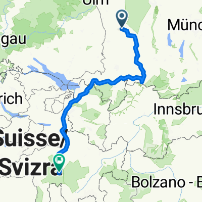
Rennradtour Hohe Schulter
A cycling route starting in Breitenbrunn, Bavaria, Germany.
Overview
About this route
Von Bedernau ins Allgäu mit Highlight-Ausblicken
- -:--
- Duration
- 120.9 km
- Distance
- 808 m
- Ascent
- 808 m
- Descent
- ---
- Avg. speed
- ---
- Max. altitude
Route quality
Waytypes & surfaces along the route
Waytypes
Quiet road
75.8 km
(63 %)
Road
25.8 km
(21 %)
Surfaces
Paved
67.4 km
(56 %)
Unpaved
0.6 km
(<1 %)
Asphalt
62.6 km
(52 %)
Paved (undefined)
4.7 km
(4 %)
Continue with Bikemap
Use, edit, or download this cycling route
You would like to ride Rennradtour Hohe Schulter or customize it for your own trip? Here is what you can do with this Bikemap route:
Free features
- Save this route as favorite or in collections
- Copy & plan your own version of this route
- Split it into stages to create a multi-day tour
- Sync your route with Garmin or Wahoo
Premium features
Free trial for 3 days, or one-time payment. More about Bikemap Premium.
- Navigate this route on iOS & Android
- Export a GPX / KML file of this route
- Create your custom printout (try it for free)
- Download this route for offline navigation
Discover more Premium features.
Get Bikemap PremiumFrom our community
Other popular routes starting in Breitenbrunn
 Oberberghöfe-Hasberg-Wanzlsee-Bronnerlehe-Ried
- Distance
- 13.1 km
- Ascent
- 54 m
- Descent
- 55 m
- Location
- Breitenbrunn, Bavaria, Germany
 Mindel-Hasberg-Oberberghöfe
- Distance
- 7.8 km
- Ascent
- 252 m
- Descent
- 257 m
- Location
- Breitenbrunn, Bavaria, Germany
 Kirchberg nach Veia da Vischnanca
- Distance
- 316.1 km
- Ascent
- 4,348 m
- Descent
- 3,942 m
- Location
- Breitenbrunn, Bavaria, Germany
 Moderate Route in Memmingerberg
- Distance
- 23.5 km
- Ascent
- 256 m
- Descent
- 212 m
- Location
- Breitenbrunn, Bavaria, Germany
 Hohenschlauer Straße 23, Breitenbrunn nach Hohenschlauer Straße 23, Breitenbrunn
- Distance
- 3.8 km
- Ascent
- 36 m
- Descent
- 39 m
- Location
- Breitenbrunn, Bavaria, Germany
 Rennradtour Hohe Schulter
- Distance
- 120.9 km
- Ascent
- 808 m
- Descent
- 808 m
- Location
- Breitenbrunn, Bavaria, Germany
 Kirchberg nach Veia da Vischnanca
- Distance
- 394.5 km
- Ascent
- 8,204 m
- Descent
- 7,799 m
- Location
- Breitenbrunn, Bavaria, Germany
 Kirchheimer Straße 13, Pfaffenhausen nach GZ12, Ursberg
- Distance
- 13.6 km
- Ascent
- 17 m
- Descent
- 56 m
- Location
- Breitenbrunn, Bavaria, Germany
Open it in the app