
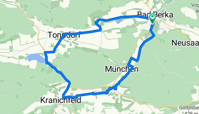
22 km rund um Bad Berka
A cycling route starting in Bad Berka, Free State of Thuringia, Germany.
Overview
About this route
Diese Rundtour ist eine leichte, auch für Anfänger gut zu radelnde Strecke.
Ausgangspunkt ist der Bahnhof Bad Berka (auch jeder andere Ausgangspunkt auf diesem Rundkurs kann gewählt werden).
Vorbei am Sportplatz und den Ilmtalradweg bis nach Kranichfeld folgen. Wege sind vorwiegend bit. Radwege, aber auch einige Passagen mit Schotter!!!
Weiter gehts zum Stausee Hohenfelden. Hier warten Wildtiergehege, Kletterwald und Badstrand auf die Radler!
Vom Stausee gehts weiter über die wenig befahrene Landstraße über Tonndorf ins wunderschöne Rundlingsdorf Tiefengruben.
Von Tiefengruben führt wieder eine wenig befahrene LAndstraße zurück zum Ausgangspunkt nach BAd Berka
- -:--
- Duration
- 22.2 km
- Distance
- 161 m
- Ascent
- 163 m
- Descent
- ---
- Avg. speed
- 345 m
- Max. altitude
Route quality
Waytypes & surfaces along the route
Waytypes
Path
7.7 km
(35 %)
Road
4.8 km
(22 %)
Surfaces
Paved
19.3 km
(87 %)
Unpaved
1.3 km
(6 %)
Asphalt
19.2 km
(86 %)
Gravel
1.1 km
(5 %)
Continue with Bikemap
Use, edit, or download this cycling route
You would like to ride 22 km rund um Bad Berka or customize it for your own trip? Here is what you can do with this Bikemap route:
Free features
- Save this route as favorite or in collections
- Copy & plan your own version of this route
- Sync your route with Garmin or Wahoo
Premium features
Free trial for 3 days, or one-time payment. More about Bikemap Premium.
- Navigate this route on iOS & Android
- Export a GPX / KML file of this route
- Create your custom printout (try it for free)
- Download this route for offline navigation
Discover more Premium features.
Get Bikemap PremiumFrom our community
Other popular routes starting in Bad Berka
 Wanderung Paulinen- Karolinenturm
- Distance
- 16.6 km
- Ascent
- 326 m
- Descent
- 327 m
- Location
- Bad Berka, Free State of Thuringia, Germany
 TH-Bad Berka-3-Türme-Weg
- Distance
- 26.3 km
- Ascent
- 590 m
- Descent
- 590 m
- Location
- Bad Berka, Free State of Thuringia, Germany
 Route von Blankenhainer Straße 42, Bad Berka
- Distance
- 15.5 km
- Ascent
- 154 m
- Descent
- 195 m
- Location
- Bad Berka, Free State of Thuringia, Germany
 Bad Berka Runde CLONED FROM ROUTE 329476
- Distance
- 46.1 km
- Ascent
- 681 m
- Descent
- 680 m
- Location
- Bad Berka, Free State of Thuringia, Germany
 Bad Berka 13.06.10
- Distance
- 46 km
- Ascent
- 663 m
- Descent
- 682 m
- Location
- Bad Berka, Free State of Thuringia, Germany
 DreiTürme
- Distance
- 16.6 km
- Ascent
- 384 m
- Descent
- 383 m
- Location
- Bad Berka, Free State of Thuringia, Germany
 50.889° N 11.264° W nach 50.892° N 11.269° W
- Distance
- 36.3 km
- Ascent
- 429 m
- Descent
- 430 m
- Location
- Bad Berka, Free State of Thuringia, Germany
 Weimarische Straße 31, Bad Berka do Straße ohne Straßennamen, Tonndorf
- Distance
- 12.3 km
- Ascent
- 172 m
- Descent
- 131 m
- Location
- Bad Berka, Free State of Thuringia, Germany
Open it in the app