

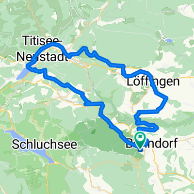
Bonndorf - Dillendorf- Boll
A cycling route starting in Bonndorf, Baden-Wurttemberg, Germany.
Overview
About this route
- 1 h 12 min
- Duration
- 22.4 km
- Distance
- 518 m
- Ascent
- 529 m
- Descent
- 18.5 km/h
- Avg. speed
- ---
- Max. altitude
Route quality
Waytypes & surfaces along the route
Waytypes
Road
9.2 km
(41 %)
Track
7.2 km
(32 %)
Surfaces
Paved
10.7 km
(48 %)
Unpaved
1.3 km
(6 %)
Paved (undefined)
6.3 km
(28 %)
Asphalt
4.5 km
(20 %)
Continue with Bikemap
Use, edit, or download this cycling route
You would like to ride Bonndorf - Dillendorf- Boll or customize it for your own trip? Here is what you can do with this Bikemap route:
Free features
- Save this route as favorite or in collections
- Copy & plan your own version of this route
- Sync your route with Garmin or Wahoo
Premium features
Free trial for 3 days, or one-time payment. More about Bikemap Premium.
- Navigate this route on iOS & Android
- Export a GPX / KML file of this route
- Create your custom printout (try it for free)
- Download this route for offline navigation
Discover more Premium features.
Get Bikemap PremiumFrom our community
Other popular routes starting in Bonndorf
 Fröhnd_Do_Wandern_Wutachschlucht
- Distance
- 12.3 km
- Ascent
- 302 m
- Descent
- 310 m
- Location
- Bonndorf, Baden-Wurttemberg, Germany
 SRW - Bonndorf - Bad Säckingen
- Distance
- 77 km
- Ascent
- 105 m
- Descent
- 679 m
- Location
- Bonndorf, Baden-Wurttemberg, Germany
 Bonndorf - Schluhsee - Lenzkirch a zpět
- Distance
- 50.5 km
- Ascent
- 628 m
- Descent
- 628 m
- Location
- Bonndorf, Baden-Wurttemberg, Germany
 Wellendingen - Badeparadies Schwarzwald - Schluchsee - Wellendingen
- Distance
- 69.8 km
- Ascent
- 759 m
- Descent
- 759 m
- Location
- Bonndorf, Baden-Wurttemberg, Germany
 Schluchtensteig Etappe 3 von der Schattenmühle nach Fischbach-Schluchsee
- Distance
- 18.2 km
- Ascent
- 882 m
- Descent
- 495 m
- Location
- Bonndorf, Baden-Wurttemberg, Germany
 Auf dem Bähnleweg mit Adrian und Karin
- Distance
- 31.5 km
- Ascent
- 209 m
- Descent
- 225 m
- Location
- Bonndorf, Baden-Wurttemberg, Germany
 KA-ZH Teil-4 neu Bonndorf-Küssnach-Zürich
- Distance
- 78.4 km
- Ascent
- 410 m
- Descent
- 786 m
- Location
- Bonndorf, Baden-Wurttemberg, Germany
 Bonndof Titisee
- Distance
- 60.1 km
- Ascent
- 721 m
- Descent
- 722 m
- Location
- Bonndorf, Baden-Wurttemberg, Germany
Open it in the app