Weimarische Straße 31, Bad Berka do Straße ohne Straßennamen, Tonndorf
- 12.3 km
- 172 m
- 131 m
- Bad Berka, Thuringia, Germany
A cycling route starting in Bad Berka, Thuringia, Germany.
Overview
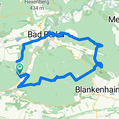
Die Route führt von Bad Berka durch den Dreiteichsgrund zur Alexanderhütte am Beginn des Dambachsgrunds.
Weiter geht es den Kohlgrund hinauf bis nach Blankenhain ... der steilste und längste Anstieg der Tour ist damit geschafft! Am höchsten Punkt der Tour ist eine schöne Blockhütte mit Grillmöglichkeit gelegen (Schlüssel über Kurverwaltung beziehbar)
Von Blankenhain geht es meist flach auf der Landstraße nach Tannroda, wo man wieder den Ilmtalradweg kreuzt. Auf diesem geht es über die Zweigburgenstadt Kranichfeld weiter nach Dienstedt. In Dienstedt ist der Wendepunkt der Etappe - wer sich nicht soviel zutraut nimmt Kranichfeld als Wendepunkt an.
Von Diensteht wieder zurück nach Kranichfeld, hinauf zum Stausee Hohenfelden. Ein Abstecher ins historische Museumsdorf lohnt sich ...
Weiter führt die Tour über die wenig befahrene Landstraße nach Tonndorf und Tiefengruben und zurück zum Ausgangsort Bad Berka
Empfehlenswerte Punkte auf der Strecke:
Bad Berka: Kirche, Kurpark, Klein Venedig
Blankenhain: Schlo
Kranichfeld: Niederburg und Oberschloss
Stedten: Stedtner Mühle
Hohenfelden: Freilichtmuseum, Kletterwald, Staussee
Tiefengruben: historisches, wunderschönes Rundlingsdorf
Streckebeschaffenheit:
meist bit. Radwege oder wenig befahrene Landstraße
teilweise geschotterte, aber gut zu fahrende Radwege
in Tiefengruben holpriges Kofsteinplaster
Viel Spaß beim Fahren !!!!
Empfehlenswerte Tour!!!
created this 15 years ago
Route quality
Track
17.7 km
(39 %)
Road
5.9 km
(13 %)
Paved
40.5 km
(89 %)
Unpaved
2.3 km
(5 %)
Asphalt
39.6 km
(87 %)
Ground
1.4 km
(3 %)
Continue with Bikemap
You would like to ride 45 km rund um Bad Berka / Blankenhain / Kranichfeld or customize it for your own trip? Here is what you can do with this Bikemap route:
Free trial for 3 days, or one-time payment. More about Bikemap Premium.
Discover more Premium features.
Get Bikemap PremiumFrom our community
Open it in the app