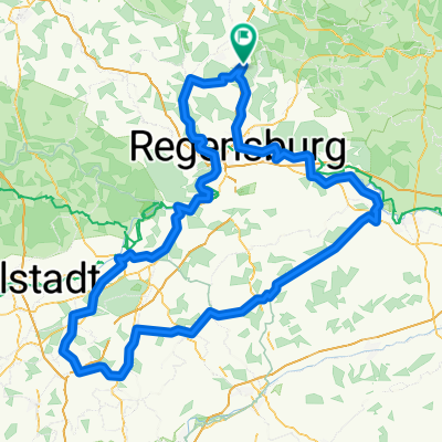
5Flüsse_2018
A cycling route starting in Maxhütte-Haidhof, Bavaria, Germany.
Overview
About this route
- -:--
- Duration
- 323.4 km
- Distance
- 474 m
- Ascent
- 474 m
- Descent
- ---
- Avg. speed
- ---
- Avg. speed
Route quality
Waytypes & surfaces along the route
Waytypes
Track
86.4 km
(27 %)
Path
84.8 km
(26 %)
Surfaces
Paved
221.3 km
(68 %)
Unpaved
82.4 km
(25 %)
Asphalt
213 km
(66 %)
Gravel
64.6 km
(20 %)
Continue with Bikemap
Use, edit, or download this cycling route
You would like to ride 5Flüsse_2018 or customize it for your own trip? Here is what you can do with this Bikemap route:
Free features
- Save this route as favorite or in collections
- Copy & plan your own version of this route
- Sync your route with Garmin or Wahoo
Premium features
Free trial for 3 days, or one-time payment. More about Bikemap Premium.
- Navigate this route on iOS & Android
- Export a GPX / KML file of this route
- Create your custom printout (try it for free)
- Download this route for offline navigation
Discover more Premium features.
Get Bikemap PremiumFrom our community
Other popular routes starting in Maxhütte-Haidhof
- SAD Runde - MH - Kallmünz - Schmidmühlen - Schwandorf - Steinberg
- Distance
- 74.6 km
- Ascent
- 397 m
- Descent
- 397 m
- Location
- Maxhütte-Haidhof, Bavaria, Germany
- Maxhütte Marienthal
- Distance
- 23.7 km
- Ascent
- 477 m
- Descent
- 479 m
- Location
- Maxhütte-Haidhof, Bavaria, Germany
- 5Flüsse_2018
- Distance
- 323.4 km
- Ascent
- 474 m
- Descent
- 474 m
- Location
- Maxhütte-Haidhof, Bavaria, Germany
- Ponholz Gasthof Alte Post, Maxhütte-Haidhof nach Hagenauer Straße 2, Maxhütte-Haidhof
- Distance
- 6.4 km
- Ascent
- 91 m
- Descent
- 89 m
- Location
- Maxhütte-Haidhof, Bavaria, Germany
- Training MTB - Nittenau - Grafenwinn
- Distance
- 44.5 km
- Ascent
- 413 m
- Descent
- 408 m
- Location
- Maxhütte-Haidhof, Bavaria, Germany
- Parkstein - MH - SAD - Weiden - Parkstein - Amberg - Regensburg
- Distance
- 238.8 km
- Ascent
- 2,355 m
- Descent
- 2,354 m
- Location
- Maxhütte-Haidhof, Bavaria, Germany
- Training - Nittenau - Karlstein
- Distance
- 48.8 km
- Ascent
- 367 m
- Descent
- 361 m
- Location
- Maxhütte-Haidhof, Bavaria, Germany
- Ponholz - Kürnberg
- Distance
- 20.2 km
- Ascent
- 180 m
- Descent
- 179 m
- Location
- Maxhütte-Haidhof, Bavaria, Germany
Open it in the app