

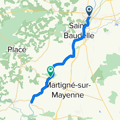
Mayenne - Château-Gontier
A cycling route starting in Mayenne, Pays de la Loire Region, France.
Overview
About this route
Camping in the park
- -:--
- Duration
- 72.6 km
- Distance
- 169 m
- Ascent
- 222 m
- Descent
- ---
- Avg. speed
- ---
- Max. altitude

Route quality
Waytypes & surfaces along the route
Waytypes
Path
53 km
(73 %)
Cycleway
7.3 km
(10 %)
Surfaces
Paved
37.8 km
(52 %)
Unpaved
30.5 km
(42 %)
Paved (undefined)
29.8 km
(41 %)
Gravel
18.2 km
(25 %)
Continue with Bikemap
Use, edit, or download this cycling route
You would like to ride Mayenne - Château-Gontier or customize it for your own trip? Here is what you can do with this Bikemap route:
Free features
- Save this route as favorite or in collections
- Copy & plan your own version of this route
- Sync your route with Garmin or Wahoo
Premium features
Free trial for 3 days, or one-time payment. More about Bikemap Premium.
- Navigate this route on iOS & Android
- Export a GPX / KML file of this route
- Create your custom printout (try it for free)
- Download this route for offline navigation
Discover more Premium features.
Get Bikemap PremiumFrom our community
Other popular routes starting in Mayenne
 J5-Camping-LesChenes
- Distance
- 42.5 km
- Ascent
- 474 m
- Descent
- 475 m
- Location
- Mayenne, Pays de la Loire Region, France
 Route reposante
- Distance
- 26.2 km
- Ascent
- 53 m
- Descent
- 72 m
- Location
- Mayenne, Pays de la Loire Region, France
 Place Juhel 6, Mayenne to Place de la Mairie 2, Damigny
- Distance
- 69.8 km
- Ascent
- 488 m
- Descent
- 496 m
- Location
- Mayenne, Pays de la Loire Region, France
 La Vélo Francette Mayenne-Laval
- Distance
- 34.9 km
- Ascent
- 99 m
- Descent
- 172 m
- Location
- Mayenne, Pays de la Loire Region, France
 J-6. Mayenne - Angers (135,5 Km)
- Distance
- 135.5 km
- Ascent
- 817 m
- Descent
- 890 m
- Location
- Mayenne, Pays de la Loire Region, France
 Mayenne Chatillon
- Distance
- 274.6 km
- Ascent
- 808 m
- Descent
- 789 m
- Location
- Mayenne, Pays de la Loire Region, France
 2018_E3
- Distance
- 100.2 km
- Ascent
- 307 m
- Descent
- 341 m
- Location
- Mayenne, Pays de la Loire Region, France
 5 Etap Tdf Mayenne - Nantes
- Distance
- 212.5 km
- Ascent
- 370 m
- Descent
- 463 m
- Location
- Mayenne, Pays de la Loire Region, France
Open it in the app