

Trainingstour Hauptstuhl, Ramstein, Weilerbach
A cycling route starting in Hauptstuhl, Rhineland-Palatinate, Germany.
Overview
About this route
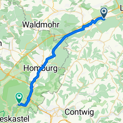
Start in KL, über Landstuhl bis Hauptstuh, dort rechts ab nach Hütschenhausen, über Ramstein nach Weilerbach und zurück nach KL. (Teilweise empfohlene Radwege benutzt, jedoch sehr grober Schotter - muss nicht sein)
- -:--
- Duration
- 61.3 km
- Distance
- 247 m
- Ascent
- 247 m
- Descent
- ---
- Avg. speed
- ---
- Max. altitude

Continue with Bikemap
Use, edit, or download this cycling route
You would like to ride Trainingstour Hauptstuhl, Ramstein, Weilerbach or customize it for your own trip? Here is what you can do with this Bikemap route:
Free features
- Save this route as favorite or in collections
- Copy & plan your own version of this route
- Sync your route with Garmin or Wahoo
Premium features
Free trial for 3 days, or one-time payment. More about Bikemap Premium.
- Navigate this route on iOS & Android
- Export a GPX / KML file of this route
- Create your custom printout (try it for free)
- Download this route for offline navigation
Discover more Premium features.
Get Bikemap PremiumFrom our community
Other popular routes starting in Hauptstuhl
 Saar-Mosel-1
- Distance
- 52.3 km
- Ascent
- 593 m
- Descent
- 490 m
- Location
- Hauptstuhl, Rhineland-Palatinate, Germany
 Bruchmühlbach Ortsrundfahrt
- Distance
- 5.5 km
- Ascent
- 0 m
- Descent
- 3 m
- Location
- Hauptstuhl, Rhineland-Palatinate, Germany
 Weilerbach - KTown - Hauptstuhl 43km Loop
- Distance
- 42.8 km
- Ascent
- 204 m
- Descent
- 203 m
- Location
- Hauptstuhl, Rhineland-Palatinate, Germany
 Exploring...Who knows??
- Distance
- 27.5 km
- Ascent
- 466 m
- Descent
- 464 m
- Location
- Hauptstuhl, Rhineland-Palatinate, Germany
 exploring
- Distance
- 29.9 km
- Ascent
- 570 m
- Descent
- 571 m
- Location
- Hauptstuhl, Rhineland-Palatinate, Germany
 bruchmühlbach / Landstuhl
- Distance
- 23.1 km
- Ascent
- 7 m
- Descent
- 66 m
- Location
- Hauptstuhl, Rhineland-Palatinate, Germany
 Am Birnbaum 25B nach Parkstraße
- Distance
- 26.3 km
- Ascent
- 208 m
- Descent
- 239 m
- Location
- Hauptstuhl, Rhineland-Palatinate, Germany
 Ohmbachsee
- Distance
- 10.7 km
- Ascent
- 40 m
- Descent
- 30 m
- Location
- Hauptstuhl, Rhineland-Palatinate, Germany
Open it in the app