

Eichelberg - Strecke
A cycling route starting in Langschlag, Lower Austria, Austria.
Overview
About this route
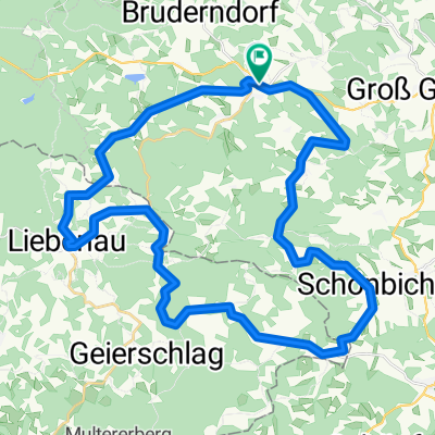
Around Aichelberg. At the beginning of the route, we pass by the natural paradise Stierhübelteich. After beautiful forest paths, we cross the federal road towards Stadelberg. From there, it's a good workout for the calves as we ascend Aichelberg. Midway up the mountain, we turn off towards the source of the Lainsitz. From there, the trail takes us back to Karlstift via forest roads.
- -:--
- Duration
- 9.3 km
- Distance
- 217 m
- Ascent
- 220 m
- Descent
- ---
- Avg. speed
- 999 m
- Max. altitude

Route quality
Waytypes & surfaces along the route
Waytypes
Track
5.7 km
(61 %)
Quiet road
2.7 km
(29 %)
Surfaces
Paved
2.3 km
(25 %)
Unpaved
3.9 km
(42 %)
Gravel
2.7 km
(29 %)
Asphalt
2.3 km
(25 %)
Continue with Bikemap
Use, edit, or download this cycling route
You would like to ride Eichelberg - Strecke or customize it for your own trip? Here is what you can do with this Bikemap route:
Free features
- Save this route as favorite or in collections
- Copy & plan your own version of this route
- Sync your route with Garmin or Wahoo
Premium features
Free trial for 3 days, or one-time payment. More about Bikemap Premium.
- Navigate this route on iOS & Android
- Export a GPX / KML file of this route
- Create your custom printout (try it for free)
- Download this route for offline navigation
Discover more Premium features.
Get Bikemap PremiumFrom our community
Other popular routes starting in Langschlag
 Am Berg 170, Langschlag nach Am Berg 170, Langschlag
- Distance
- 6.8 km
- Ascent
- 126 m
- Descent
- 174 m
- Location
- Langschlag, Lower Austria, Austria
 Eichelberg - Strecke
- Distance
- 9.3 km
- Ascent
- 217 m
- Descent
- 220 m
- Location
- Langschlag, Lower Austria, Austria
 Panorama
- Distance
- 40.7 km
- Ascent
- 826 m
- Descent
- 830 m
- Location
- Langschlag, Lower Austria, Austria
 2 Ländertour
- Distance
- 58.7 km
- Ascent
- 1,027 m
- Descent
- 1,022 m
- Location
- Langschlag, Lower Austria, Austria
 Naturparkwanderweg(10000 Schritte)
- Distance
- 7.1 km
- Ascent
- 178 m
- Descent
- 178 m
- Location
- Langschlag, Lower Austria, Austria
 Freiwald-Strecke lang
- Distance
- 38.7 km
- Ascent
- 844 m
- Descent
- 843 m
- Location
- Langschlag, Lower Austria, Austria
 Tannermoor
- Distance
- 38.7 km
- Ascent
- 757 m
- Descent
- 759 m
- Location
- Langschlag, Lower Austria, Austria
 Nordwaldtour
- Distance
- 38.2 km
- Ascent
- 197 m
- Descent
- 625 m
- Location
- Langschlag, Lower Austria, Austria
Open it in the app