

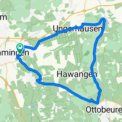
Memmingen - Ottobeuren - Westerheim
A cycling route starting in Memmingen, Bavaria, Germany.
Overview
About this route
Rundstrecke durch das Unterallgäu
Achtung: 400m über Feld zwischen Westerheim und Ungerhausen
- -:--
- Duration
- 26.5 km
- Distance
- 186 m
- Ascent
- 171 m
- Descent
- ---
- Avg. speed
- 684 m
- Max. altitude
Route quality
Waytypes & surfaces along the route
Waytypes
Path
14.1 km
(53 %)
Track
6.1 km
(23 %)
Surfaces
Paved
22.5 km
(85 %)
Unpaved
2.7 km
(10 %)
Asphalt
22.3 km
(84 %)
Gravel
2.1 km
(8 %)
Continue with Bikemap
Use, edit, or download this cycling route
You would like to ride Memmingen - Ottobeuren - Westerheim or customize it for your own trip? Here is what you can do with this Bikemap route:
Free features
- Save this route as favorite or in collections
- Copy & plan your own version of this route
- Sync your route with Garmin or Wahoo
Premium features
Free trial for 3 days, or one-time payment. More about Bikemap Premium.
- Navigate this route on iOS & Android
- Export a GPX / KML file of this route
- Create your custom printout (try it for free)
- Download this route for offline navigation
Discover more Premium features.
Get Bikemap PremiumFrom our community
Other popular routes starting in Memmingen
 2011-08-06 - MM - Illerbeuren - Altusried - Bad Grönenbach - Woringen - MM
- Distance
- 52.9 km
- Ascent
- 416 m
- Descent
- 415 m
- Location
- Memmingen, Bavaria, Germany
 All4: Memmingen - Haidgau; 68,8km 530hm
- Distance
- 67.3 km
- Ascent
- 672 m
- Descent
- 616 m
- Location
- Memmingen, Bavaria, Germany
 45_MM-Tannheim-Bonlanden-Fellheim-MM
- Distance
- 44.8 km
- Ascent
- 202 m
- Descent
- 201 m
- Location
- Memmingen, Bavaria, Germany
 Hexenhäusle Tour
- Distance
- 15.9 km
- Ascent
- 291 m
- Descent
- 223 m
- Location
- Memmingen, Bavaria, Germany
 Geroldstraße 16, Memmingen to Geroldstraße 16, Memmingen
- Distance
- 27.6 km
- Ascent
- 1 m
- Descent
- 1 m
- Location
- Memmingen, Bavaria, Germany
 Leichte MTB-Hausrunde
- Distance
- 37.9 km
- Ascent
- 303 m
- Descent
- 301 m
- Location
- Memmingen, Bavaria, Germany
 Von Memmingen bis Westerheim
- Distance
- 34.7 km
- Ascent
- 251 m
- Descent
- 251 m
- Location
- Memmingen, Bavaria, Germany
 Memmingen-Kronburg
- Distance
- 57.7 km
- Ascent
- 340 m
- Descent
- 341 m
- Location
- Memmingen, Bavaria, Germany
Open it in the app