
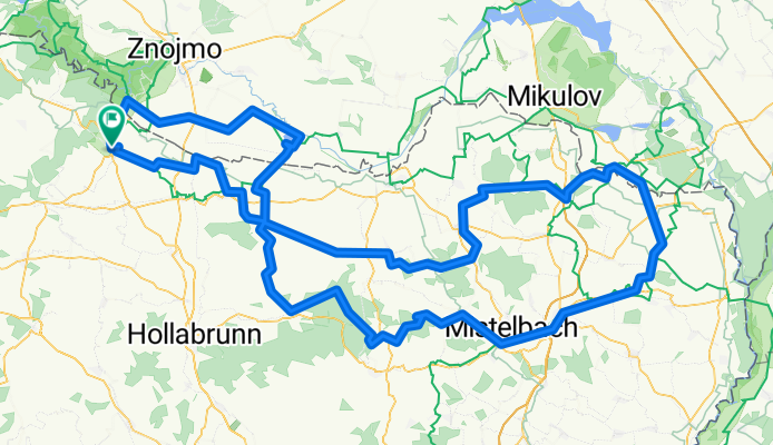
Overview
About this route
- -:--
- Duration
- 221.7 km
- Distance
- 1,135 m
- Ascent
- 1,136 m
- Descent
- ---
- Avg. speed
- ---
- Max. altitude

Part of
IVV_2018_Retz
3 stages
Route quality
Waytypes & surfaces along the route
Waytypes
Road
70.9 km
(32 %)
Track
62.1 km
(28 %)
Surfaces
Paved
117.5 km
(53 %)
Unpaved
26.6 km
(12 %)
Asphalt
97.5 km
(44 %)
Paved (undefined)
20 km
(9 %)
Continue with Bikemap
Use, edit, or download this cycling route
You would like to ride IVV_2018_Retz_210_die Epische or customize it for your own trip? Here is what you can do with this Bikemap route:
Free features
- Save this route as favorite or in collections
- Copy & plan your own version of this route
- Split it into stages to create a multi-day tour
- Sync your route with Garmin or Wahoo
Premium features
Free trial for 3 days, or one-time payment. More about Bikemap Premium.
- Navigate this route on iOS & Android
- Export a GPX / KML file of this route
- Create your custom printout (try it for free)
- Download this route for offline navigation
Discover more Premium features.
Get Bikemap PremiumFrom our community
Other popular routes starting in Retz
 RETZ Chardonnay Route
- Distance
- 48.7 km
- Ascent
- 503 m
- Descent
- 485 m
- Location
- Retz, Lower Austria, Austria
 3. Weinradroute - Chardonnay aktuell
- Distance
- 48.9 km
- Ascent
- 452 m
- Descent
- 453 m
- Location
- Retz, Lower Austria, Austria
 Chardonnay kurz
- Distance
- 14.3 km
- Ascent
- 144 m
- Descent
- 147 m
- Location
- Retz, Lower Austria, Austria
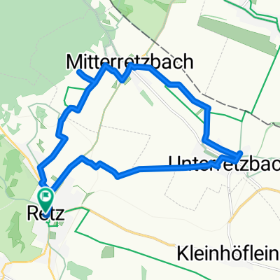
 1 Retz-Hardegg-Cizoiv-Lukov-Planeta-Knizeci vrch-Mitterretzbach
- Distance
- 54 km
- Ascent
- 847 m
- Descent
- 846 m
- Location
- Retz, Lower Austria, Austria
![In Velo Veritas 140km [Garmin Import]](https://media.bikemap.net/routes/4476873/staticmaps/in_52324e2d-fca4-42f4-9298-afee002e5724_400x400_bikemap-2021-3D-static.png) In Velo Veritas 140km [Garmin Import]
In Velo Veritas 140km [Garmin Import]- Distance
- 142.3 km
- Ascent
- 689 m
- Descent
- 691 m
- Location
- Retz, Lower Austria, Austria
 2 Wein und Kultur Radweg
- Distance
- 58.4 km
- Ascent
- 584 m
- Descent
- 599 m
- Location
- Retz, Lower Austria, Austria
 Retz, Hardegg, Riegersburg, Retz
- Distance
- 51 km
- Ascent
- 761 m
- Descent
- 761 m
- Location
- Retz, Lower Austria, Austria
 Unterretzbachrunde 2
- Distance
- 26.5 km
- Ascent
- 224 m
- Descent
- 224 m
- Location
- Retz, Lower Austria, Austria
Open it in the app