

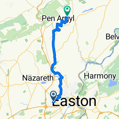
Easton D&L run
A cycling route starting in Palmer Heights, Pennsylvania, United States.
Overview
About this route
- -:--
- Duration
- 32.8 km
- Distance
- 245 m
- Ascent
- 245 m
- Descent
- ---
- Avg. speed
- ---
- Max. altitude

Route quality
Waytypes & surfaces along the route
Waytypes
Cycleway
19.7 km
(60 %)
Quiet road
4.9 km
(15 %)
Surfaces
Paved
15.4 km
(47 %)
Unpaved
7.9 km
(24 %)
Asphalt
14.8 km
(45 %)
Gravel
6.9 km
(21 %)
Continue with Bikemap
Use, edit, or download this cycling route
You would like to ride Easton D&L run or customize it for your own trip? Here is what you can do with this Bikemap route:
Free features
- Save this route as favorite or in collections
- Copy & plan your own version of this route
- Sync your route with Garmin or Wahoo
Premium features
Free trial for 3 days, or one-time payment. More about Bikemap Premium.
- Navigate this route on iOS & Android
- Export a GPX / KML file of this route
- Create your custom printout (try it for free)
- Download this route for offline navigation
Discover more Premium features.
Get Bikemap PremiumFrom our community
Other popular routes starting in Palmer Heights
 From Easton to Bangor
- Distance
- 30.1 km
- Ascent
- 374 m
- Descent
- 247 m
- Location
- Palmer Heights, Pennsylvania, United States
 Easton D&L run
- Distance
- 32.8 km
- Ascent
- 245 m
- Descent
- 245 m
- Location
- Palmer Heights, Pennsylvania, United States
 Friendly Tavern Lane 1019, Easton to Northwood Avenue 26, Easton
- Distance
- 14.2 km
- Ascent
- 70 m
- Descent
- 66 m
- Location
- Palmer Heights, Pennsylvania, United States
 Recovered Route
- Distance
- 11.5 km
- Ascent
- 94 m
- Descent
- 96 m
- Location
- Palmer Heights, Pennsylvania, United States
 3723 Easton Nazareth Hwy, Easton to 117 S Eighth St, Stroudsburg
- Distance
- 47.8 km
- Ascent
- 682 m
- Descent
- 656 m
- Location
- Palmer Heights, Pennsylvania, United States
Open it in the app