

Overview
About this route
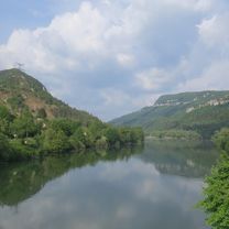
From the campsite at Matafelon, descend down to Thoirette, follow the west bank of the L'Ain river north to the dam bridge, then continue along the east bank of the reservoir for a few more kilometers before returning to Matafelon
- -:--
- Duration
- 33.6 km
- Distance
- 434 m
- Ascent
- 425 m
- Descent
- ---
- Avg. speed
- ---
- Max. altitude

Part of
Jura
1 stage
Route quality
Waytypes & surfaces along the route
Waytypes
Road
6.4 km
(19 %)
Quiet road
3.7 km
(11 %)
Surfaces
Paved
0.3 km
(1 %)
Unpaved
2.4 km
(7 %)
Ground
2.4 km
(7 %)
Asphalt
0.3 km
(1 %)
Undefined
30.9 km
(92 %)
Continue with Bikemap
Use, edit, or download this cycling route
You would like to ride Matafelon-Tour or customize it for your own trip? Here is what you can do with this Bikemap route:
Free features
- Save this route as favorite or in collections
- Copy & plan your own version of this route
- Sync your route with Garmin or Wahoo
Premium features
Free trial for 3 days, or one-time payment. More about Bikemap Premium.
- Navigate this route on iOS & Android
- Export a GPX / KML file of this route
- Create your custom printout (try it for free)
- Download this route for offline navigation
Discover more Premium features.
Get Bikemap PremiumFrom our community
Other popular routes starting in Izernore
 Granges-Saint-Vérand
- Distance
- 79.7 km
- Ascent
- 398 m
- Descent
- 507 m
- Location
- Izernore, Auvergne-Rhône-Alpes, France
 Granges 54 km
- Distance
- 55 km
- Ascent
- 671 m
- Descent
- 671 m
- Location
- Izernore, Auvergne-Rhône-Alpes, France
 Thoirette - Sault-Brénaz
- Distance
- 67.1 km
- Ascent
- 269 m
- Descent
- 358 m
- Location
- Izernore, Auvergne-Rhône-Alpes, France
 Matafelon-Tour
- Distance
- 33.6 km
- Ascent
- 434 m
- Descent
- 425 m
- Location
- Izernore, Auvergne-Rhône-Alpes, France
 Thoirette - Censeau
- Distance
- 97.6 km
- Ascent
- 1,038 m
- Descent
- 499 m
- Location
- Izernore, Auvergne-Rhône-Alpes, France
 Thoirette East
- Distance
- 55.4 km
- Ascent
- 967 m
- Descent
- 968 m
- Location
- Izernore, Auvergne-Rhône-Alpes, France
 Etappe 13 (Zutphen-Avignon)
- Distance
- 72.7 km
- Ascent
- 785 m
- Descent
- 832 m
- Location
- Izernore, Auvergne-Rhône-Alpes, France
 Signal du Cuiron
- Distance
- 33.2 km
- Ascent
- 604 m
- Descent
- 589 m
- Location
- Izernore, Auvergne-Rhône-Alpes, France
Open it in the app