

Rhone-Tal
Bergtour bei Valence
A cycling route starting in Beaumont-Monteux, Auvergne-Rhône-Alpes, France.
Overview
About this route
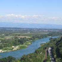
From the campsite at Chateauneuf-sur-Isere on the Isere cycle route to La Roche-du-Glun on the Rhone, then up the small mountain road to Saint-Romain-de-Lerps and to the mountain summit (with chapel). Then down the wide road to Saint-Peray and over the Rhone bridge at Valence. Through Valence to the Rhone cycle route heading north and back to the campsite.
- -:--
- Duration
- 52.6 km
- Distance
- 562 m
- Ascent
- 562 m
- Descent
- ---
- Avg. speed
- ---
- Max. altitude

Part of
Rhone-Tal
1 stage
Route quality
Waytypes & surfaces along the route
Waytypes
Quiet road
19.5 km
(37 %)
Road
12.6 km
(24 %)
Surfaces
Paved
20 km
(38 %)
Unpaved
0.5 km
(1 %)
Asphalt
20 km
(38 %)
Gravel
0.5 km
(1 %)
Undefined
32.1 km
(61 %)
Continue with Bikemap
Use, edit, or download this cycling route
You would like to ride Bergtour bei Valence or customize it for your own trip? Here is what you can do with this Bikemap route:
Free features
- Save this route as favorite or in collections
- Copy & plan your own version of this route
- Sync your route with Garmin or Wahoo
Premium features
Free trial for 3 days, or one-time payment. More about Bikemap Premium.
- Navigate this route on iOS & Android
- Export a GPX / KML file of this route
- Create your custom printout (try it for free)
- Download this route for offline navigation
Discover more Premium features.
Get Bikemap PremiumFrom our community
Other popular routes starting in Beaumont-Monteux
 4. Chemin des Communaux 480, Châteauneuf-sur-Isère to Place Fernand Vinson 3, Saint-Julien-en-Saint-Alban
- Distance
- 49.6 km
- Ascent
- 256 m
- Descent
- 246 m
- Location
- Beaumont-Monteux, Auvergne-Rhône-Alpes, France
 Valence - St. Sylvestre
- Distance
- 63 km
- Ascent
- 627 m
- Descent
- 624 m
- Location
- Beaumont-Monteux, Auvergne-Rhône-Alpes, France
 mont
mont- Distance
- 65 km
- Ascent
- 267 m
- Descent
- 292 m
- Location
- Beaumont-Monteux, Auvergne-Rhône-Alpes, France
 Bergtour bei Valence
- Distance
- 52.6 km
- Ascent
- 562 m
- Descent
- 562 m
- Location
- Beaumont-Monteux, Auvergne-Rhône-Alpes, France
 Valence - Colombier-le-Vieux
- Distance
- 80.7 km
- Ascent
- 564 m
- Descent
- 560 m
- Location
- Beaumont-Monteux, Auvergne-Rhône-Alpes, France
 Rhône Tag 5, Abschnitt 1
- Distance
- 16.3 km
- Ascent
- 41 m
- Descent
- 36 m
- Location
- Beaumont-Monteux, Auvergne-Rhône-Alpes, France
 Day 4 Harmony Camping Cruas Chemin des Communaux 480, Châteauneuf-sur-Isère to Chemin du Camping, Cruas
- Distance
- 59.1 km
- Ascent
- 281 m
- Descent
- 317 m
- Location
- Beaumont-Monteux, Auvergne-Rhône-Alpes, France
 LE SOLEIL FRUITE do ANcone DE LILE BLANC
- Distance
- 57.3 km
- Ascent
- 128 m
- Descent
- 117 m
- Location
- Beaumont-Monteux, Auvergne-Rhône-Alpes, France
Open it in the app