

1003000St Etienne Cuines
A cycling route starting in Saint-Etienne-de-Cuines, Auvergne-Rhône-Alpes, France.
Overview
About this route
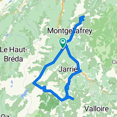
Climbs of Montvernier, Col De Glandon, Croix Fer, Col Du Mollard
- -:--
- Duration
- 100.2 km
- Distance
- 2,984 m
- Ascent
- 2,983 m
- Descent
- ---
- Avg. speed
- ---
- Max. altitude

Route quality
Waytypes & surfaces along the route
Waytypes
Road
34.1 km
(34 %)
Quiet road
8 km
(8 %)
Surfaces
Paved
32.1 km
(32 %)
Unpaved
1 km
(1 %)
Asphalt
32.1 km
(32 %)
Ground
1 km
(1 %)
Undefined
67.1 km
(67 %)
Continue with Bikemap
Use, edit, or download this cycling route
You would like to ride 1003000St Etienne Cuines or customize it for your own trip? Here is what you can do with this Bikemap route:
Free features
- Save this route as favorite or in collections
- Copy & plan your own version of this route
- Split it into stages to create a multi-day tour
- Sync your route with Garmin or Wahoo
Premium features
Free trial for 3 days, or one-time payment. More about Bikemap Premium.
- Navigate this route on iOS & Android
- Export a GPX / KML file of this route
- Create your custom printout (try it for free)
- Download this route for offline navigation
Discover more Premium features.
Get Bikemap PremiumFrom our community
Other popular routes starting in Saint-Etienne-de-Cuines
 More Recon
- Distance
- 43.2 km
- Ascent
- 2,645 m
- Descent
- 2,632 m
- Location
- Saint-Etienne-de-Cuines, Auvergne-Rhône-Alpes, France
 Lacets de Montvernier, D77B, Pontamafrey-Montpascal, Franciaország
- Distance
- 82.4 km
- Ascent
- 1,965 m
- Descent
- 1,969 m
- Location
- Saint-Etienne-de-Cuines, Auvergne-Rhône-Alpes, France
 col du Glandon
- Distance
- 47.8 km
- Ascent
- 1,590 m
- Descent
- 1,590 m
- Location
- Saint-Etienne-de-Cuines, Auvergne-Rhône-Alpes, France
 Le Etape
- Distance
- 114.3 km
- Ascent
- 3,556 m
- Descent
- 3,557 m
- Location
- Saint-Etienne-de-Cuines, Auvergne-Rhône-Alpes, France
 Stäfa - Tarifa Stage #4 Sainte Marie de Cuines - L'Alpe d'Huez - Le Bourg de Oisans
- Distance
- 84.5 km
- Ascent
- 2,558 m
- Descent
- 2,324 m
- Location
- Saint-Etienne-de-Cuines, Auvergne-Rhône-Alpes, France
 5-ANNECY
- Distance
- 129.9 km
- Ascent
- 2,314 m
- Descent
- 2,273 m
- Location
- Saint-Etienne-de-Cuines, Auvergne-Rhône-Alpes, France
 Glandon Croix de Fer
- Distance
- 69.3 km
- Ascent
- 2,006 m
- Descent
- 2,008 m
- Location
- Saint-Etienne-de-Cuines, Auvergne-Rhône-Alpes, France
 1003000St Etienne Cuines
- Distance
- 100.2 km
- Ascent
- 2,984 m
- Descent
- 2,983 m
- Location
- Saint-Etienne-de-Cuines, Auvergne-Rhône-Alpes, France
Open it in the app