

MTB-Tour: Von St. Valentin a.d. Haide nach Rojen und zurück
A cycling route starting in Graun im Vinschgau, Trentino-Alto Adige, Italy.
Overview
About this route
- -:--
- Duration
- 24.7 km
- Distance
- 948 m
- Ascent
- 937 m
- Descent
- ---
- Avg. speed
- ---
- Max. altitude

Route quality
Waytypes & surfaces along the route
Waytypes
Track
11.3 km
(46 %)
Quiet road
6.2 km
(25 %)
Surfaces
Paved
11.1 km
(45 %)
Unpaved
10.9 km
(44 %)
Asphalt
11.1 km
(45 %)
Gravel
9.4 km
(38 %)
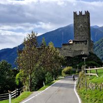
Route highlights
Points of interest along the route

Photo after 9.8 km
Rojen
Continue with Bikemap
Use, edit, or download this cycling route
You would like to ride MTB-Tour: Von St. Valentin a.d. Haide nach Rojen und zurück or customize it for your own trip? Here is what you can do with this Bikemap route:
Free features
- Save this route as favorite or in collections
- Copy & plan your own version of this route
- Sync your route with Garmin or Wahoo
Premium features
Free trial for 3 days, or one-time payment. More about Bikemap Premium.
- Navigate this route on iOS & Android
- Export a GPX / KML file of this route
- Create your custom printout (try it for free)
- Download this route for offline navigation
Discover more Premium features.
Get Bikemap PremiumFrom our community
Other popular routes starting in Graun im Vinschgau
 Od Haidersee přes Nauders do Pfunds
- Distance
- 41.1 km
- Ascent
- 259 m
- Descent
- 735 m
- Location
- Graun im Vinschgau, Trentino-Alto Adige, Italy
 Tag 5: Bergab durch Südtirol
- Distance
- 122.6 km
- Ascent
- 310 m
- Descent
- 1,609 m
- Location
- Graun im Vinschgau, Trentino-Alto Adige, Italy
 Etappe 1 Reschen - Schlanders
- Distance
- 43.2 km
- Ascent
- 320 m
- Descent
- 1,132 m
- Location
- Graun im Vinschgau, Trentino-Alto Adige, Italy
 MTB-Tour: Von St. Valentin a.d. Haide nach Rojen und zurück
- Distance
- 24.7 km
- Ascent
- 948 m
- Descent
- 937 m
- Location
- Graun im Vinschgau, Trentino-Alto Adige, Italy
 Curon Venosta-Glurns/Glorenza
- Distance
- 19.7 km
- Ascent
- 142 m
- Descent
- 733 m
- Location
- Graun im Vinschgau, Trentino-Alto Adige, Italy
 Stilfserjoch und Umbrailpass
- Distance
- 106 km
- Ascent
- 2,505 m
- Descent
- 2,507 m
- Location
- Graun im Vinschgau, Trentino-Alto Adige, Italy
 Lago di Resia - Chiavenna
- Distance
- 151.3 km
- Ascent
- 1,161 m
- Descent
- 2,424 m
- Location
- Graun im Vinschgau, Trentino-Alto Adige, Italy
 Reschensee Nauders
- Distance
- 36.9 km
- Ascent
- 530 m
- Descent
- 527 m
- Location
- Graun im Vinschgau, Trentino-Alto Adige, Italy
Open it in the app