elg:// Payerbach - Wiener Neustadt
A cycling route starting in Payerbach, Lower Austria, Austria.
Overview
About this route
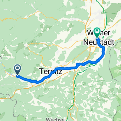
PAYERBACH - WIENER NEUSTADT
Schwarzatalradweg, Thermenradweg
Bahnhof Payerbach Reichenau - Gloggnitz - Ternitz - Neunkirchen - Loipersbach - Breitenau - Bahnhof Wiener Neustadt
(Titelbild: © Bwag/Wikimedia)
- -:--
- Duration
- 45.3 km
- Distance
- 29 m
- Ascent
- 252 m
- Descent
- ---
- Avg. speed
- ---
- Max. altitude
Route quality
Waytypes & surfaces along the route
Waytypes
Quiet road
21.2 km
(47 %)
Cycleway
7.4 km
(16 %)
Surfaces
Paved
36.7 km
(81 %)
Unpaved
0.8 km
(2 %)
Asphalt
36.6 km
(81 %)
Gravel
0.6 km
(1 %)
Continue with Bikemap
Use, edit, or download this cycling route
You would like to ride elg:// Payerbach - Wiener Neustadt or customize it for your own trip? Here is what you can do with this Bikemap route:
Free features
- Save this route as favorite or in collections
- Copy & plan your own version of this route
- Sync your route with Garmin or Wahoo
Premium features
Free trial for 3 days, or one-time payment. More about Bikemap Premium.
- Navigate this route on iOS & Android
- Export a GPX / KML file of this route
- Create your custom printout (try it for free)
- Download this route for offline navigation
Discover more Premium features.
Get Bikemap PremiumFrom our community
Other popular routes starting in Payerbach
- Kreuzbergstrecke
- Distance
- 30.3 km
- Ascent
- 796 m
- Descent
- 793 m
- Location
- Payerbach, Lower Austria, Austria
- Payerbach - Mürztal - Annaberg - Lilienfeld
- Distance
- 113.8 km
- Ascent
- 1,248 m
- Descent
- 1,365 m
- Location
- Payerbach, Lower Austria, Austria
- Rund um die Rax
- Distance
- 126.9 km
- Ascent
- 1,240 m
- Descent
- 1,241 m
- Location
- Payerbach, Lower Austria, Austria
- Payerbach - Höllental - Kernhof - Freinsattel - Preiner Gscheid
- Distance
- 160.7 km
- Ascent
- 1,525 m
- Descent
- 1,525 m
- Location
- Payerbach, Lower Austria, Austria
- Rax Retour Tour
- Distance
- 119.2 km
- Ascent
- 853 m
- Descent
- 1,137 m
- Location
- Payerbach, Lower Austria, Austria
- Trainingsstrecke über Speckbacherhütte
- Distance
- 33.5 km
- Ascent
- 987 m
- Descent
- 987 m
- Location
- Payerbach, Lower Austria, Austria
- Payerbach-Baden ueber Hubertussee
- Distance
- 169.5 km
- Ascent
- 1,616 m
- Descent
- 1,877 m
- Location
- Payerbach, Lower Austria, Austria
- Payerbach - Kirchschlag
- Distance
- 60.5 km
- Ascent
- 1,465 m
- Descent
- 1,524 m
- Location
- Payerbach, Lower Austria, Austria
Open it in the app