

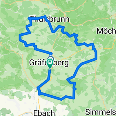
Lillachtal
A cycling route starting in Gräfenberg, Bavaria, Germany.
Overview
About this route
Worth seeing; sinter terraces, calcareous tuff brook, half-timbered houses in Gräfenberg
- -:--
- Duration
- 20.8 km
- Distance
- 375 m
- Ascent
- 375 m
- Descent
- ---
- Avg. speed
- ---
- Max. altitude

Route quality
Waytypes & surfaces along the route
Waytypes
Track
10.4 km
(50 %)
Quiet road
5 km
(24 %)
Surfaces
Paved
7.5 km
(36 %)
Unpaved
9.1 km
(44 %)
Asphalt
5.8 km
(28 %)
Gravel
3.7 km
(18 %)
Continue with Bikemap
Use, edit, or download this cycling route
You would like to ride Lillachtal or customize it for your own trip? Here is what you can do with this Bikemap route:
Free features
- Save this route as favorite or in collections
- Copy & plan your own version of this route
- Sync your route with Garmin or Wahoo
Premium features
Free trial for 3 days, or one-time payment. More about Bikemap Premium.
- Navigate this route on iOS & Android
- Export a GPX / KML file of this route
- Create your custom printout (try it for free)
- Download this route for offline navigation
Discover more Premium features.
Get Bikemap PremiumFrom our community
Other popular routes starting in Gräfenberg
 Bahnhofstraße 44, Gräfenberg nach Baiersdorf
- Distance
- 25.4 km
- Ascent
- 682 m
- Descent
- 803 m
- Location
- Gräfenberg, Bavaria, Germany
 Brauerei_-_Tour_FO_7
- Distance
- 38.9 km
- Ascent
- 623 m
- Descent
- 623 m
- Location
- Gräfenberg, Bavaria, Germany
 Gräfenberg-Rüsselbach
- Distance
- 25.9 km
- Ascent
- 431 m
- Descent
- 495 m
- Location
- Gräfenberg, Bavaria, Germany
 Lillachtal
- Distance
- 20.8 km
- Ascent
- 375 m
- Descent
- 375 m
- Location
- Gräfenberg, Bavaria, Germany
 Fränkische Schweiz - 3 Bäche
- Distance
- 31.9 km
- Ascent
- 377 m
- Descent
- 374 m
- Location
- Gräfenberg, Bavaria, Germany
 20161122_094638.gpx
- Distance
- 14.4 km
- Ascent
- 305 m
- Descent
- 302 m
- Location
- Gräfenberg, Bavaria, Germany
 Kasberg 8, Gräfenberg nach Kasberg 8, Gräfenberg
- Distance
- 4.3 km
- Ascent
- 59 m
- Descent
- 60 m
- Location
- Gräfenberg, Bavaria, Germany
 Oberlandtour
- Distance
- 33.9 km
- Ascent
- 594 m
- Descent
- 596 m
- Location
- Gräfenberg, Bavaria, Germany
Open it in the app