

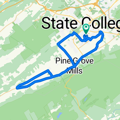
State College-Bellefonte
A cycling route starting in State College, Pennsylvania, United States.
Overview
About this route
- 1 h 32 min
- Duration
- 20.6 km
- Distance
- 378 m
- Ascent
- 492 m
- Descent
- 13.5 km/h
- Avg. speed
- ---
- Max. altitude

Route photos

Route quality
Waytypes & surfaces along the route
Waytypes
Quiet road
9.9 km
(48 %)
Road
6.4 km
(31 %)
Surfaces
Paved
18.6 km
(90 %)
Unpaved
2.1 km
(10 %)
Asphalt
17.7 km
(86 %)
Gravel
1.9 km
(9 %)
Continue with Bikemap
Use, edit, or download this cycling route
You would like to ride State College-Bellefonte or customize it for your own trip? Here is what you can do with this Bikemap route:
Free features
- Save this route as favorite or in collections
- Copy & plan your own version of this route
- Sync your route with Garmin or Wahoo
Premium features
Free trial for 3 days, or one-time payment. More about Bikemap Premium.
- Navigate this route on iOS & Android
- Export a GPX / KML file of this route
- Create your custom printout (try it for free)
- Download this route for offline navigation
Discover more Premium features.
Get Bikemap PremiumFrom our community
Other popular routes starting in State College
 Allegheny front loop
- Distance
- 51.7 km
- Ascent
- 852 m
- Descent
- 854 m
- Location
- State College, Pennsylvania, United States
 State College-Bellefonte
- Distance
- 20.6 km
- Ascent
- 378 m
- Descent
- 492 m
- Location
- State College, Pennsylvania, United States
 Spring Creek Canyon Loop
- Distance
- 37.3 km
- Ascent
- 245 m
- Descent
- 244 m
- Location
- State College, Pennsylvania, United States
 Bike 12 miles
- Distance
- 19.9 km
- Ascent
- 195 m
- Descent
- 188 m
- Location
- State College, Pennsylvania, United States
 Scenic Town/Farm route and Baileyville
- Distance
- 45.7 km
- Ascent
- 222 m
- Descent
- 222 m
- Location
- State College, Pennsylvania, United States
 bike route
- Distance
- 7 km
- Ascent
- 64 m
- Descent
- 67 m
- Location
- State College, Pennsylvania, United States
 Way Fruit Farm (30miles)
- Distance
- 51.3 km
- Ascent
- 304 m
- Descent
- 305 m
- Location
- State College, Pennsylvania, United States
 State College Spring Mills
- Distance
- 72.5 km
- Ascent
- 409 m
- Descent
- 409 m
- Location
- State College, Pennsylvania, United States
Open it in the app