

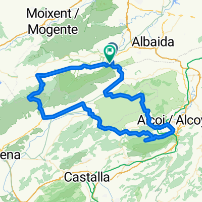
Vuelta a El Moro (Beneixama - Fontanars )
A cycling route starting in Ontinyent, Valencia, Spain.
Overview
About this route
Climb to El Moro from Beneixama (departure from Ontinyent, and descent to Fontanars. Return to Ontinyent.
- -:--
- Duration
- 59.5 km
- Distance
- 837 m
- Ascent
- 841 m
- Descent
- ---
- Avg. speed
- ---
- Max. altitude

Route quality
Waytypes & surfaces along the route
Waytypes
Road
17.8 km
(30 %)
Track
5.9 km
(10 %)
Surfaces
Paved
13.1 km
(22 %)
Unpaved
1.2 km
(2 %)
Asphalt
13.1 km
(22 %)
Gravel
1.2 km
(2 %)
Undefined
45.2 km
(76 %)
Continue with Bikemap
Use, edit, or download this cycling route
You would like to ride Vuelta a El Moro (Beneixama - Fontanars ) or customize it for your own trip? Here is what you can do with this Bikemap route:
Free features
- Save this route as favorite or in collections
- Copy & plan your own version of this route
- Sync your route with Garmin or Wahoo
Premium features
Free trial for 3 days, or one-time payment. More about Bikemap Premium.
- Navigate this route on iOS & Android
- Export a GPX / KML file of this route
- Create your custom printout (try it for free)
- Download this route for offline navigation
Discover more Premium features.
Get Bikemap PremiumFrom our community
Other popular routes starting in Ontinyent
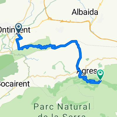
 Moixent-Achter
- Distance
- 52.9 km
- Ascent
- 885 m
- Descent
- 896 m
- Location
- Ontinyent, Valencia, Spain
 Vuelta a El Moro (Beneixama - Fontanars )
- Distance
- 59.5 km
- Ascent
- 837 m
- Descent
- 841 m
- Location
- Ontinyent, Valencia, Spain
 Font Roja
- Distance
- 102.9 km
- Ascent
- 1,511 m
- Descent
- 1,519 m
- Location
- Ontinyent, Valencia, Spain
 Vuelta corta Ontinyent
- Distance
- 12 km
- Ascent
- 181 m
- Descent
- 183 m
- Location
- Ontinyent, Valencia, Spain
 Torrater (por senda Enginyers) y Pla de Ponce (por Bocairent)
- Distance
- 56.3 km
- Ascent
- 747 m
- Descent
- 787 m
- Location
- Ontinyent, Valencia, Spain
 Ontinyent - L'Orxa - Daimus
- Distance
- 73.6 km
- Ascent
- 840 m
- Descent
- 1,200 m
- Location
- Ontinyent, Valencia, Spain
 Ontinyent - Les Cabes (Mariola) por el Torrater
- Distance
- 20.7 km
- Ascent
- 1,049 m
- Descent
- 188 m
- Location
- Ontinyent, Valencia, Spain
 casa Aitana recto
- Distance
- 3.9 km
- Ascent
- 103 m
- Descent
- 9 m
- Location
- Ontinyent, Valencia, Spain
Open it in the app