

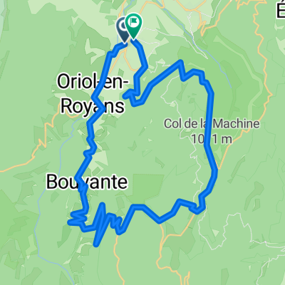
Combe Laval, Col de la Bataille Loop
A cycling route starting in Saint-Jean-en-Royans, Auvergne-Rhône-Alpes, France.
Overview
About this route
- -:--
- Duration
- 64.3 km
- Distance
- 1,507 m
- Ascent
- 1,512 m
- Descent
- ---
- Avg. speed
- ---
- Max. altitude

Route highlights
Points of interest along the route
Point of interest after 9.2 km
Col Gaudissart - 889 metres
Point of interest after 10.8 km
Combe Laval
Point of interest after 15.7 km
Col de la Machine - 1011 metres
Point of interest after 21.7 km
Col de Taillebourse - 1165 metres
Point of interest after 23 km
Col de la Portette - 1175 metres
Point of interest after 30 km
Pas de Logue - 1312 metres
Point of interest after 37.3 km
Col de la Bataille - 1313 metres
Continue with Bikemap
Use, edit, or download this cycling route
You would like to ride Combe Laval, Col de la Bataille Loop or customize it for your own trip? Here is what you can do with this Bikemap route:
Free features
- Save this route as favorite or in collections
- Copy & plan your own version of this route
- Sync your route with Garmin or Wahoo
Premium features
Free trial for 3 days, or one-time payment. More about Bikemap Premium.
- Navigate this route on iOS & Android
- Export a GPX / KML file of this route
- Create your custom printout (try it for free)
- Download this route for offline navigation
Discover more Premium features.
Get Bikemap PremiumFrom our community
Other popular routes starting in Saint-Jean-en-Royans
 Combe Laval, Col de la Bataille Loop
- Distance
- 64.3 km
- Ascent
- 1,507 m
- Descent
- 1,512 m
- Location
- Saint-Jean-en-Royans, Auvergne-Rhône-Alpes, France
 Combe Lavel Rundtour 50km
- Distance
- 37.8 km
- Ascent
- 1,821 m
- Descent
- 1,807 m
- Location
- Saint-Jean-en-Royans, Auvergne-Rhône-Alpes, France
 Col de Rousset Plus 10 More Vercors Cols from Bataille
- Distance
- 128.2 km
- Ascent
- 2,159 m
- Descent
- 2,169 m
- Location
- Saint-Jean-en-Royans, Auvergne-Rhône-Alpes, France
 Combe Lavel Rundtour 50km
- Distance
- 41.5 km
- Ascent
- 1,613 m
- Descent
- 1,600 m
- Location
- Saint-Jean-en-Royans, Auvergne-Rhône-Alpes, France
 Combe Lavel Rundtour 50km
- Distance
- 37.8 km
- Ascent
- 1,821 m
- Descent
- 1,807 m
- Location
- Saint-Jean-en-Royans, Auvergne-Rhône-Alpes, France
 Vercors 4
- Distance
- 120.8 km
- Ascent
- 2,221 m
- Descent
- 2,221 m
- Location
- Saint-Jean-en-Royans, Auvergne-Rhône-Alpes, France
 Avenue du Sert 2, Saint-Jean-en-Royans nach Avenue du Sert 4, Saint-Jean-en-Royans
- Distance
- 63.3 km
- Ascent
- 1,498 m
- Descent
- 1,496 m
- Location
- Saint-Jean-en-Royans, Auvergne-Rhône-Alpes, France
 Avenue du Sert 2, Saint-Jean-en-Royans nach Avenue du Sert 2, Saint-Jean-en-Royans
- Distance
- 77.4 km
- Ascent
- 2,019 m
- Descent
- 2,018 m
- Location
- Saint-Jean-en-Royans, Auvergne-Rhône-Alpes, France
Open it in the app