

Trainingsstrecke über Speckbacherhütte
A cycling route starting in Payerbach, Lower Austria, Austria.
Overview
About this route
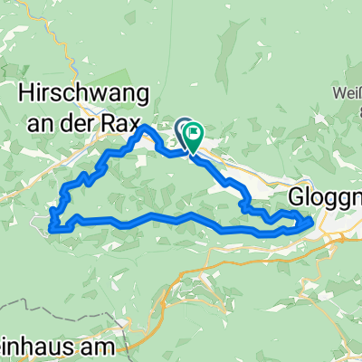
It starts in Reichenau; the climb to the Spackbacher Hut is demanding, the last half kilometer is tough, it's the steepest part of the entire route.
If you don't want to ride on the road, like me, there are several hiking trails and forest roads that you can't see on the maps here, so I couldn't mark them.
Going downhill you can test your brakes! But beware, sometimes it's better to get off the bike before you end up falling involuntarily!!!
Arriving in Heufeld, you continue on asphalt to the next climb; once at the top, you have a wonderful view over Payerbach and Reichenau.
After Schneedorfl, after gaining more altitude, you come back to a forest road; here begins a nature reserve closed in winter, please do respect the gates and barriers "we are guests in the forest".
Once you've overcome that, it goes downhill back to Reichenau.
- -:--
- Duration
- 33.5 km
- Distance
- 987 m
- Ascent
- 987 m
- Descent
- ---
- Avg. speed
- ---
- Max. altitude

Continue with Bikemap
Use, edit, or download this cycling route
You would like to ride Trainingsstrecke über Speckbacherhütte or customize it for your own trip? Here is what you can do with this Bikemap route:
Free features
- Save this route as favorite or in collections
- Copy & plan your own version of this route
- Sync your route with Garmin or Wahoo
Premium features
Free trial for 3 days, or one-time payment. More about Bikemap Premium.
- Navigate this route on iOS & Android
- Export a GPX / KML file of this route
- Create your custom printout (try it for free)
- Download this route for offline navigation
Discover more Premium features.
Get Bikemap PremiumFrom our community
Other popular routes starting in Payerbach
 Payerbach - Mürztal - Annaberg - Lilienfeld
- Distance
- 113.8 km
- Ascent
- 1,248 m
- Descent
- 1,365 m
- Location
- Payerbach, Lower Austria, Austria
 Kreuzbergstrecke Gloggnitz
- Distance
- 28.5 km
- Ascent
- 1,099 m
- Descent
- 1,091 m
- Location
- Payerbach, Lower Austria, Austria
 Kreuzberg-Strecke
- Distance
- 31.1 km
- Ascent
- 780 m
- Descent
- 780 m
- Location
- Payerbach, Lower Austria, Austria
 Rec Kreuzbergstrecke + Heimweg
- Distance
- 56.2 km
- Ascent
- 1,184 m
- Descent
- 1,211 m
- Location
- Payerbach, Lower Austria, Austria
 Payerbach - Mürztal - Hainfeld
- Distance
- 124.5 km
- Ascent
- 1,391 m
- Descent
- 1,462 m
- Location
- Payerbach, Lower Austria, Austria
 Kreuzbergstecke vom Bahnhof Payerbach-Reichenau (Ohne Singletrails)
- Distance
- 32.4 km
- Ascent
- 1,143 m
- Descent
- 1,143 m
- Location
- Payerbach, Lower Austria, Austria
 Trainingsstrecke über Speckbacherhütte
- Distance
- 33.5 km
- Ascent
- 987 m
- Descent
- 987 m
- Location
- Payerbach, Lower Austria, Austria
 Mariazeller-Runde
- Distance
- 146.1 km
- Ascent
- 1,468 m
- Descent
- 1,468 m
- Location
- Payerbach, Lower Austria, Austria
Open it in the app