Venø havn-Klosterhede Plantage
A cycling route starting in Struer Municipality, Central Jutland, Denmark.
Overview
About this route
- -:--
- Duration
- 15.4 km
- Distance
- 84 m
- Ascent
- 42 m
- Descent
- ---
- Avg. speed
- ---
- Avg. speed
Route quality
Waytypes & surfaces along the route
Waytypes
Quiet road
9.7 km
(63 %)
Road
4.4 km
(29 %)
Surfaces
Paved
10.7 km
(70 %)
Unpaved
2.5 km
(16 %)
Asphalt
10.7 km
(70 %)
Gravel
2.3 km
(15 %)
Continue with Bikemap
Use, edit, or download this cycling route
You would like to ride Venø havn-Klosterhede Plantage or customize it for your own trip? Here is what you can do with this Bikemap route:
Free features
- Save this route as favorite or in collections
- Copy & plan your own version of this route
- Sync your route with Garmin or Wahoo
Premium features
Free trial for 3 days, or one-time payment. More about Bikemap Premium.
- Navigate this route on iOS & Android
- Export a GPX / KML file of this route
- Create your custom printout (try it for free)
- Download this route for offline navigation
Discover more Premium features.
Get Bikemap PremiumFrom our community
Other popular routes starting in Struer Municipality
- Venø - Cykelruterne pü smüøerne
- Distance
- 16.7 km
- Ascent
- ---
- Descent
- ---
- Location
- Struer Municipality, Central Jutland, Denmark
- Venø havn-Klosterhede Plantage
- Distance
- 15.4 km
- Ascent
- 84 m
- Descent
- 42 m
- Location
- Struer Municipality, Central Jutland, Denmark
- Limfjorden rundt
- Distance
- 618.1 km
- Ascent
- 2,193 m
- Descent
- 2,193 m
- Location
- Struer Municipality, Central Jutland, Denmark
- Struer - Thisted
- Distance
- 77.6 km
- Ascent
- 418 m
- Descent
- 417 m
- Location
- Struer Municipality, Central Jutland, Denmark
- Søndags tur
- Distance
- 138 km
- Ascent
- 302 m
- Descent
- 310 m
- Location
- Struer Municipality, Central Jutland, Denmark
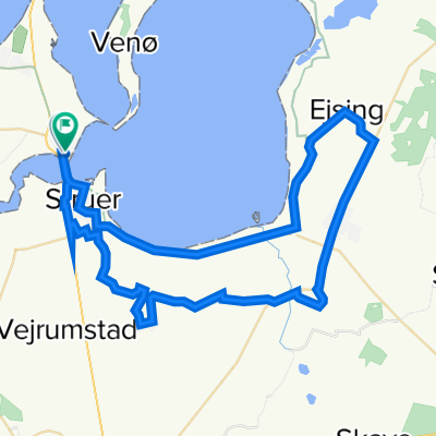
- Post Danmark Rundt 2015 1.etape
- Distance
- 167.2 km
- Ascent
- 332 m
- Descent
- 315 m
- Location
- Struer Municipality, Central Jutland, Denmark
- Asp til Fredrikshavn
- Distance
- 203.6 km
- Ascent
- 248 m
- Descent
- 287 m
- Location
- Struer Municipality, Central Jutland, Denmark
- Struer - Heltborg
- Distance
- 44.6 km
- Ascent
- 221 m
- Descent
- 192 m
- Location
- Struer Municipality, Central Jutland, Denmark