

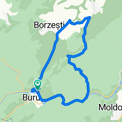
Circuit Buru-Ocolis-Muntele Baisorii
A cycling route starting in Moldoveneşti, Cluj County, Romania.
Overview
About this route
Buru-Lungesti-Vidolm-Ocolis-Runc-Lunca Larga-Statiunea Muntele Baisorii-Muntele Baisorii-Baisoara-Iara-Surduc-Buru.
- -:--
- Duration
- 66.7 km
- Distance
- 1,063 m
- Ascent
- 1,063 m
- Descent
- ---
- Avg. speed
- ---
- Max. altitude
Route quality
Waytypes & surfaces along the route
Waytypes
Track
9.3 km
(14 %)
Road
8.7 km
(13 %)
Surfaces
Paved
45.3 km
(68 %)
Unpaved
4 km
(6 %)
Asphalt
45.3 km
(68 %)
Gravel
2.7 km
(4 %)
Continue with Bikemap
Use, edit, or download this cycling route
You would like to ride Circuit Buru-Ocolis-Muntele Baisorii or customize it for your own trip? Here is what you can do with this Bikemap route:
Free features
- Save this route as favorite or in collections
- Copy & plan your own version of this route
- Sync your route with Garmin or Wahoo
Premium features
Free trial for 3 days, or one-time payment. More about Bikemap Premium.
- Navigate this route on iOS & Android
- Export a GPX / KML file of this route
- Create your custom printout (try it for free)
- Download this route for offline navigation
Discover more Premium features.
Get Bikemap PremiumFrom our community
Other popular routes starting in Moldoveneşti
 Várfalva-Csegez-Sz.Hidas-Torockószentgyörgy
- Distance
- 39.7 km
- Ascent
- 850 m
- Descent
- 826 m
- Location
- Moldoveneşti, Cluj County, Romania
 Pietroasa - Rachis
- Distance
- 55.3 km
- Ascent
- 811 m
- Descent
- 811 m
- Location
- Moldoveneşti, Cluj County, Romania
 Borrev - Jarabanya - Aranyosronk
- Distance
- 67 km
- Ascent
- 1,371 m
- Descent
- 1,375 m
- Location
- Moldoveneşti, Cluj County, Romania
 Nyugati Transalpina
- Distance
- 218.9 km
- Ascent
- 4,813 m
- Descent
- 4,813 m
- Location
- Moldoveneşti, Cluj County, Romania
 Cheile Borzesti
- Distance
- 10.2 km
- Ascent
- 397 m
- Descent
- 397 m
- Location
- Moldoveneşti, Cluj County, Romania
 Buru - Cheile Borzesti- 08.12.2019
- Distance
- 16 km
- Ascent
- 373 m
- Descent
- 372 m
- Location
- Moldoveneşti, Cluj County, Romania
 2020.07.22_Nyugati körtúra_2
- Distance
- 141.7 km
- Ascent
- 2,233 m
- Descent
- 2,267 m
- Location
- Moldoveneşti, Cluj County, Romania
 Moldovenesti -Padurea Sloboda - Buru - Valea ierii - Moldovenesti
- Distance
- 156.9 km
- Ascent
- 1,125 m
- Descent
- 1,125 m
- Location
- Moldoveneşti, Cluj County, Romania
Open it in the app