

catllaras_pere_2018
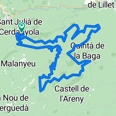
A cycling route starting in Sant Julià de Cerdanyola, Catalonia, Spain.
Overview
About this route
catllaras_pere
- -:--
- Duration
- 43.6 km
- Distance
- 1,530 m
- Ascent
- 1,530 m
- Descent
- ---
- Avg. speed
- ---
- Max. altitude

Route quality
Waytypes & surfaces along the route
Waytypes
Track
41.4 km
(95 %)
Path
1.7 km
(4 %)
Quiet road
0.4 km
(1 %)
Surfaces
Unpaved
41.9 km
(96 %)
Ground
31.8 km
(73 %)
Gravel
8.3 km
(19 %)
Route highlights
Points of interest along the route
Point of interest after 4.7 km
COLLADA DE LES BASSOTES
Point of interest after 11.7 km
FONT DE LES CABANELLES
Drinking water after 18.1 km
REFUGI DE LS CLUSA
Point of interest after 23.1 km
COLL PAN
Point of interest after 24.1 km
COLLADA DEL PLA DE L´ORRI
Point of interest after 24.4 km
ROCA DE CATLLARAS
Drinking water after 26.3 km
FONT DEL PRAT GESPADOR
Photo after 27.8 km
MIRADOR DE LA LLUNA
Drinking water after 34.2 km
FONT
Continue with Bikemap
Use, edit, or download this cycling route
You would like to ride catllaras_pere_2018 or customize it for your own trip? Here is what you can do with this Bikemap route:
Free features
- Save this route as favorite or in collections
- Copy & plan your own version of this route
- Sync your route with Garmin or Wahoo
Premium features
Free trial for 3 days, or one-time payment. More about Bikemap Premium.
- Navigate this route on iOS & Android
- Export a GPX / KML file of this route
- Create your custom printout (try it for free)
- Download this route for offline navigation
Discover more Premium features.
Get Bikemap PremiumFrom our community
Other popular routes starting in Sant Julià de Cerdanyola
 Aa la Masella!
- Distance
- 34.8 km
- Ascent
- 1,253 m
- Descent
- 473 m
- Location
- Sant Julià de Cerdanyola, Catalonia, Spain
 La Pobla de Lillet - La Molina - Camprodón
- Distance
- 95.6 km
- Ascent
- 1,461 m
- Descent
- 1,326 m
- Location
- Sant Julià de Cerdanyola, Catalonia, Spain
 COLL DE LA CREUETA (La Pobla de Lillet)
- Distance
- 17.3 km
- Ascent
- 1,022 m
- Descent
- 96 m
- Location
- Sant Julià de Cerdanyola, Catalonia, Spain
 La Pobla de Lillet-Bourg Madame
- Distance
- 62.5 km
- Ascent
- 1,683 m
- Descent
- 1,344 m
- Location
- Sant Julià de Cerdanyola, Catalonia, Spain
 catllaras_pere_2018
- Distance
- 43.6 km
- Ascent
- 1,530 m
- Descent
- 1,530 m
- Location
- Sant Julià de Cerdanyola, Catalonia, Spain
 Pobla de Lillet Gossol Tuixen Organya
- Distance
- 90.8 km
- Ascent
- 1,574 m
- Descent
- 1,858 m
- Location
- Sant Julià de Cerdanyola, Catalonia, Spain
 Les Barraques i la collada
- Distance
- 100.3 km
- Ascent
- 2,132 m
- Descent
- 2,143 m
- Location
- Sant Julià de Cerdanyola, Catalonia, Spain
 Nou de Bergada - Vilada - Borreda - S.Jaume Frontanya - La Pobla Lillet - Guardiola Bergada - Saldes - COLL PRADELL - Fumanya - Figols - Sant Corneli - Nou Berg
- Distance
- 97.9 km
- Ascent
- 2,102 m
- Descent
- 2,081 m
- Location
- Sant Julià de Cerdanyola, Catalonia, Spain
Open it in the app