

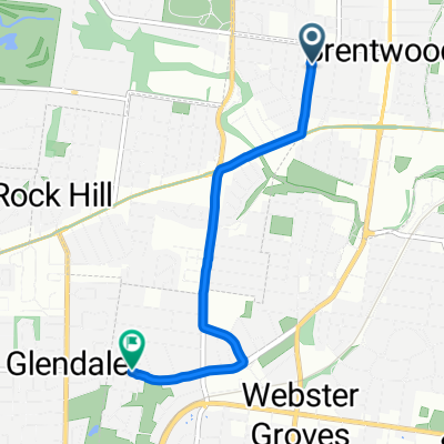
Rock Hill to Forest Park
A cycling route starting in Brentwood, Missouri, United States.
Overview
About this route
- 1 h 6 min
- Duration
- 22.7 km
- Distance
- 236 m
- Ascent
- 243 m
- Descent
- 20.7 km/h
- Avg. speed
- ---
- Max. altitude

Continue with Bikemap
Use, edit, or download this cycling route
You would like to ride Rock Hill to Forest Park or customize it for your own trip? Here is what you can do with this Bikemap route:
Free features
- Save this route as favorite or in collections
- Copy & plan your own version of this route
- Sync your route with Garmin or Wahoo
Premium features
Free trial for 3 days, or one-time payment. More about Bikemap Premium.
- Navigate this route on iOS & Android
- Export a GPX / KML file of this route
- Create your custom printout (try it for free)
- Download this route for offline navigation
Discover more Premium features.
Get Bikemap PremiumFrom our community
Other popular routes starting in Brentwood
 Rock Hill to Forest Park
- Distance
- 22.7 km
- Ascent
- 236 m
- Descent
- 243 m
- Location
- Brentwood, Missouri, United States
 50 loop in St. Louis
- Distance
- 53.3 km
- Ascent
- 225 m
- Descent
- 224 m
- Location
- Brentwood, Missouri, United States
 Morning ride with Nate
- Distance
- 33 km
- Ascent
- 279 m
- Descent
- 288 m
- Location
- Brentwood, Missouri, United States
 Easy ride in Brentwood around Forest Park
- Distance
- 14.5 km
- Ascent
- 128 m
- Descent
- 129 m
- Location
- Brentwood, Missouri, United States
 Church to Home
- Distance
- 11.8 km
- Ascent
- 99 m
- Descent
- 92 m
- Location
- Brentwood, Missouri, United States
 Restful route in Glendale
- Distance
- 6.4 km
- Ascent
- 198 m
- Descent
- 151 m
- Location
- Brentwood, Missouri, United States
 2444 Bremerton Rd, Brentwood to 2 Hull Ave, Webster Groves
- Distance
- 3.8 km
- Ascent
- 45 m
- Descent
- 42 m
- Location
- Brentwood, Missouri, United States
 Clayton-Wildwood 40mile city ride
- Distance
- 63.9 km
- Ascent
- 750 m
- Descent
- 750 m
- Location
- Brentwood, Missouri, United States
Open it in the app