

Quick Ride
A cycling route starting in Chelsea, Massachusetts, United States of America.
Overview
About this route
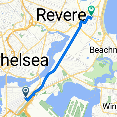
Orient Heights to Mav to Ferry Port back to Orient Heights
- -:--
- Duration
- 5 km
- Distance
- 20 m
- Ascent
- 22 m
- Descent
- ---
- Avg. speed
- ---
- Avg. speed

Route quality
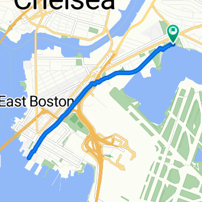
Waytypes & surfaces along the route
Waytypes
Cycleway
3.4 km
(69 %)
Quiet road
0.9 km
(19 %)
Surfaces
Paved
4.8 km
(95 %)
Asphalt
4.5 km
(89 %)
Paved (undefined)
0.2 km
(3 %)
Route highlights
Points of interest along the route
Point of interest after 3.8 km
stop and do some calisthenics
Continue with Bikemap
Use, edit, or download this cycling route
You would like to ride Quick Ride or customize it for your own trip? Here is what you can do with this Bikemap route:
Free features
- Save this route as favorite or in collections
- Copy & plan your own version of this route
- Sync your route with Garmin or Wahoo
Premium features
Free trial for 3 days, or one-time payment. More about Bikemap Premium.
- Navigate this route on iOS & Android
- Export a GPX / KML file of this route
- Create your custom printout (try it for free)
- Download this route for offline navigation
Discover more Premium features.
Get Bikemap PremiumFrom our community
Other popular routes starting in Chelsea
 Transportation Way, Boston to 10 Ocean Ave, Revere
- Distance
- 7.8 km
- Ascent
- 26 m
- Descent
- 28 m
- Location
- Chelsea, Massachusetts, United States of America
 7/26 Boston to Brookfield MA
- Distance
- 117.8 km
- Ascent
- 1,312 m
- Descent
- 1,088 m
- Location
- Chelsea, Massachusetts, United States of America
 kayla’s house vibes 👻⭐️
- Distance
- 4.8 km
- Ascent
- 42 m
- Descent
- 34 m
- Location
- Chelsea, Massachusetts, United States of America
 Border Street 126, Boston to Long Wharf 66, Boston
- Distance
- 30.2 km
- Ascent
- 120 m
- Descent
- 88 m
- Location
- Chelsea, Massachusetts, United States of America
 US1 Boston - Ellisville
- Distance
- 96.6 km
- Ascent
- 314 m
- Descent
- 314 m
- Location
- Chelsea, Massachusetts, United States of America
 Quick Ride
- Distance
- 5 km
- Ascent
- 20 m
- Descent
- 22 m
- Location
- Chelsea, Massachusetts, United States of America
 75 Addison St, Chelsea to Northern Strand Community Trail, Everett
- Distance
- 3.4 km
- Ascent
- 15 m
- Descent
- 16 m
- Location
- Chelsea, Massachusetts, United States of America
 Bike Week Day 4: East Boston Greenway
- Distance
- 7.3 km
- Ascent
- 24 m
- Descent
- 23 m
- Location
- Chelsea, Massachusetts, United States of America
Open it in the app