

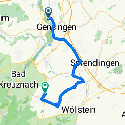
Rheinhessen-Tour -2
A cycling route starting in Grolsheim, Rhineland-Palatinate, Germany.
Overview
About this route
- -:--
- Duration
- 22.5 km
- Distance
- 254 m
- Ascent
- 165 m
- Descent
- ---
- Avg. speed
- ---
- Max. altitude
Route quality
Waytypes & surfaces along the route
Waytypes
Track
6.3 km
(28 %)
Path
4.7 km
(21 %)
Surfaces
Paved
18.2 km
(81 %)
Unpaved
1.1 km
(5 %)
Asphalt
16.2 km
(72 %)
Paved (undefined)
2 km
(9 %)
Continue with Bikemap
Use, edit, or download this cycling route
You would like to ride Rheinhessen-Tour -2 or customize it for your own trip? Here is what you can do with this Bikemap route:
Free features
- Save this route as favorite or in collections
- Copy & plan your own version of this route
- Sync your route with Garmin or Wahoo
Premium features
Free trial for 3 days, or one-time payment. More about Bikemap Premium.
- Navigate this route on iOS & Android
- Export a GPX / KML file of this route
- Create your custom printout (try it for free)
- Download this route for offline navigation
Discover more Premium features.
Get Bikemap PremiumFrom our community
Other popular routes starting in Grolsheim
 Auf der Weide 20, Grolsheim nach Zum Uhlenhorst 14, Sankt Goar
- Distance
- 37.7 km
- Ascent
- 554 m
- Descent
- 425 m
- Location
- Grolsheim, Rhineland-Palatinate, Germany
 Gensingen - Appelbachtal - Mörsfeld - Flonheim - Wolfsheim - Ober-Hilbersheim - Gensingen
- Distance
- 84.5 km
- Ascent
- 544 m
- Descent
- 541 m
- Location
- Grolsheim, Rhineland-Palatinate, Germany
 Auf der Weide 20A, Grolsheim nach Binger Weg, Hackenheim
- Distance
- 25.1 km
- Ascent
- 184 m
- Descent
- 122 m
- Location
- Grolsheim, Rhineland-Palatinate, Germany
 Gensingen - Wöllstein - Orbis - Gerbach - Appelbachtal - Sprendlingen - Gensingen
- Distance
- 82.3 km
- Ascent
- 444 m
- Descent
- 444 m
- Location
- Grolsheim, Rhineland-Palatinate, Germany
 H22_2
H22_2- Distance
- 54.3 km
- Ascent
- 652 m
- Descent
- 542 m
- Location
- Grolsheim, Rhineland-Palatinate, Germany
 Rheinhessen-Tour -2
- Distance
- 22.5 km
- Ascent
- 254 m
- Descent
- 165 m
- Location
- Grolsheim, Rhineland-Palatinate, Germany
 Ernst-Ludwig-Straße 11, Gensingen nach Hafenstraße, Bingen am Rhein
- Distance
- 11.6 km
- Ascent
- 98 m
- Descent
- 115 m
- Location
- Grolsheim, Rhineland-Palatinate, Germany
 Mainzer Straße, Grolsheim nach Mainzer Straße, Grolsheim
- Distance
- 36.6 km
- Ascent
- 580 m
- Descent
- 580 m
- Location
- Grolsheim, Rhineland-Palatinate, Germany
Open it in the app