


SoTo 2018/22: Katzwinkel/Sieg - Bad Laasphe
A cycling route starting in Katzwinkel, Rhineland-Palatinate, Germany.
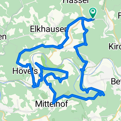
Overview
About this route
0
Katzwinkel - Wingendorf - Kirchen - Mudersbach - Siegen - Netphen - Obernautalsperre - Forsthaus Hohenroth - Siegquelle - Lahnquelle - Banfe - Bad Laasphe
- -:--
- Duration
- 66.2 km
- Distance
- 744 m
- Ascent
- 669 m
- Descent
- ---
- Avg. speed
- ---
- Max. altitude
Trike&Trike
created this 8 years ago
Route quality
Waytypes & surfaces along the route
Waytypes
Road
31.8 km
48 %
Quiet road
10.6 km
16 %
Surfaces
Paved
53 km
(80 %)
Unpaved
2 km
(3 %)
Asphalt
46.3 km
70 %
Paved (undefined)
6.6 km
10 %
Route highlights
Points of interest along the route
Accommodation after 0 km
Landgasthof Schneller
Drinking water after 6.4 km
Sieg
Photo after 6.9 km
St. Michael Kirche
Photo after 6.9 km
Stadtburg Kirchen
Photo after 7.1 km
Lutherkirche
Drinking water after 15.5 km
Sieg
Drinking water after 22 km
Sieg
Point of interest after 24.8 km
Siegsteg mit Gefälle, aber ohne Gegenverkehr!
Point of interest after 26.6 km
Passierbare Baustelle
Point of interest after 28.9 km
Kein Café in Sicht!
Point of interest after 31.4 km
Pause
Photo after 37 km
Staumauer mit Ausblick
Drinking water after 37.9 km
Obernautalsperre
Photo after 42.9 km
Ausblick 'gen Rothaargebirge
Photo after 66.1 km
Stadtkirche
Photo after 66.1 km
Königsstraße mit Brunnen und schönen Fachwerkhäusern
Point of interest after 66.1 km
Tolles Abendessen im Restaurant "Zum Hirsch"
Drinking water after 66.1 km
Lahn
Accommodation after 66.2 km
Schicke Pension Klein - super! Dazu auch noch Blasmusikbegrüßung - schließlich ist "Walachei"
Continue with Bikemap
Use, edit, or download this cycling route
You would like to ride SoTo 2018/22: Katzwinkel/Sieg - Bad Laasphe or customize it for your own trip? Here is what you can do with this Bikemap route:
Free features
- Save this route as favorite or in collections
- Copy & plan your own version of this route
- Sync your route with Garmin or Wahoo
Premium features
Free trial for 3 days, or one-time payment. More about Bikemap Premium.
- Navigate this route on iOS & Android
- Export a GPX / KML file of this route
- Create your custom printout (try it for free)
- Download this route for offline navigation
Discover more Premium features.
Get Bikemap PremiumFrom our community
Other popular routes starting in Katzwinkel


 Walmenroth, Schlangenweg, Mittelhof, Durwidchen, Vohwinkel, Oberhövels, Katzwinkel0
- 32.2 km
- 790 m
- 841 m
- Katzwinkel, Rhineland-Palatinate, Germany
 Friedrichshüttenstraße 16, Kirchen (Sieg) nach Friedrichshüttenstraße 1, Kirchen (Sieg)1
- 56.4 km
- 720 m
- 727 m
- Katzwinkel, Rhineland-Palatinate, Germany
 Höhenstraße 18, Kirchen (Sieg) nach Höhenstraße 20A, Kirchen (Sieg)0
- 50.9 km
- 2,020 m
- 2,026 m
- Katzwinkel, Rhineland-Palatinate, Germany
 Höhenstraße 20A, Kirchen (Sieg) nach Höhenstraße 20A, Kirchen (Sieg)0
- 19.1 km
- 872 m
- 870 m
- Katzwinkel, Rhineland-Palatinate, Germany


Open it in the app