

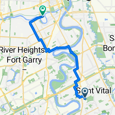
Goolie Run
A cycling route starting in Winnipeg, Manitoba, Canada.
Overview
About this route
- -:--
- Duration
- 274.3 km
- Distance
- 70 m
- Ascent
- 77 m
- Descent
- ---
- Avg. speed
- ---
- Max. altitude

Route quality
Waytypes & surfaces along the route
Waytypes
Quiet road
203 km
(74 %)
Road
11 km
(4 %)
Surfaces
Paved
19.2 km
(7 %)
Unpaved
54.9 km
(20 %)
Gravel
54.9 km
(20 %)
Paved (undefined)
11 km
(4 %)
Continue with Bikemap
Use, edit, or download this cycling route
You would like to ride Goolie Run or customize it for your own trip? Here is what you can do with this Bikemap route:
Free features
- Save this route as favorite or in collections
- Copy & plan your own version of this route
- Split it into stages to create a multi-day tour
- Sync your route with Garmin or Wahoo
Premium features
Free trial for 3 days, or one-time payment. More about Bikemap Premium.
- Navigate this route on iOS & Android
- Export a GPX / KML file of this route
- Create your custom printout (try it for free)
- Download this route for offline navigation
Discover more Premium features.
Get Bikemap PremiumFrom our community
Other popular routes starting in Winnipeg
 Ride Around Winnipeg
- Distance
- 12.8 km
- Ascent
- 34 m
- Descent
- 36 m
- Location
- Winnipeg, Manitoba, Canada
 Forks Market Rd, Winnipeg to Hearthwood Grove, Winnipeg
- Distance
- 14.5 km
- Ascent
- 126 m
- Descent
- 130 m
- Location
- Winnipeg, Manitoba, Canada
 50k Route Waverley West
- Distance
- 50.4 km
- Ascent
- 59 m
- Descent
- 60 m
- Location
- Winnipeg, Manitoba, Canada
 Saxon Bay, Winnipeg to Chancellor Matheson Rd, Winnipeg
- Distance
- 7.5 km
- Ascent
- 34 m
- Descent
- 42 m
- Location
- Winnipeg, Manitoba, Canada
 Kildonan - City Center loop
- Distance
- 32.2 km
- Ascent
- 21 m
- Descent
- 21 m
- Location
- Winnipeg, Manitoba, Canada
 Snail-like route in Winnipeg
- Distance
- 3.6 km
- Ascent
- 73 m
- Descent
- 83 m
- Location
- Winnipeg, Manitoba, Canada
 Osborne St N, Winnipeg to Osborne St N, Winnipeg
- Distance
- 32.9 km
- Ascent
- 85 m
- Descent
- 91 m
- Location
- Winnipeg, Manitoba, Canada
 Winnipeg St Vital to Eastgate
- Distance
- 12.9 km
- Ascent
- 23 m
- Descent
- 20 m
- Location
- Winnipeg, Manitoba, Canada
Open it in the app