

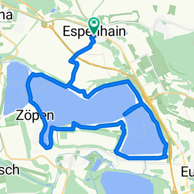
Hainer See + Umgebung
A cycling route starting in Espenhain, Saxony, Germany.
Overview
About this route
Kein Kopfsteipflaster, keine Feldwege, 100 % Asphalt;
Um den Hainer See asphaltierter Radweg ohne KFZ, Richtung Borna z.T. Bundesstraße wenig frequentiert
- -:--
- Duration
- 36.1 km
- Distance
- 121 m
- Ascent
- 122 m
- Descent
- ---
- Avg. speed
- ---
- Max. altitude

Route quality
Waytypes & surfaces along the route
Waytypes
Track
10.1 km
(28 %)
Path
7.2 km
(20 %)
Surfaces
Paved
26 km
(72 %)
Unpaved
3.6 km
(10 %)
Asphalt
25.6 km
(71 %)
Unpaved (undefined)
1.4 km
(4 %)
Continue with Bikemap
Use, edit, or download this cycling route
You would like to ride Hainer See + Umgebung or customize it for your own trip? Here is what you can do with this Bikemap route:
Free features
- Save this route as favorite or in collections
- Copy & plan your own version of this route
- Sync your route with Garmin or Wahoo
Premium features
Free trial for 3 days, or one-time payment. More about Bikemap Premium.
- Navigate this route on iOS & Android
- Export a GPX / KML file of this route
- Create your custom printout (try it for free)
- Download this route for offline navigation
Discover more Premium features.
Get Bikemap PremiumFrom our community
Other popular routes starting in Espenhain
 Galgenweg, Rötha nach Galgenweg, Rötha
- Distance
- 23.4 km
- Ascent
- 99 m
- Descent
- 107 m
- Location
- Espenhain, Saxony, Germany
 Vier Seen im Leipziger Süden
- Distance
- 24.9 km
- Ascent
- 101 m
- Descent
- 103 m
- Location
- Espenhain, Saxony, Germany
 Um den Hainer See
- Distance
- 22.2 km
- Ascent
- 108 m
- Descent
- 107 m
- Location
- Espenhain, Saxony, Germany
 Kollegentour
- Distance
- 35.2 km
- Ascent
- 86 m
- Descent
- 83 m
- Location
- Espenhain, Saxony, Germany
 Rundkurs Hainer See
- Distance
- 42.9 km
- Ascent
- 122 m
- Descent
- 125 m
- Location
- Espenhain, Saxony, Germany
 Hainer See nach Störmthaler See
- Distance
- 7.8 km
- Ascent
- 51 m
- Descent
- 56 m
- Location
- Espenhain, Saxony, Germany
 Hainer See nach Zwenkau
- Distance
- 16.4 km
- Ascent
- 36 m
- Descent
- 32 m
- Location
- Espenhain, Saxony, Germany
 Thielrunde 2015
- Distance
- 39 km
- Ascent
- 105 m
- Descent
- 104 m
- Location
- Espenhain, Saxony, Germany
Open it in the app