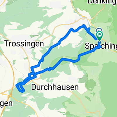
Rund Spaichingen
A cycling route starting in Spaichingen, Baden-Wurttemberg, Germany.
Overview
About this route
From Spaichingen, mostly parallel to the B14 on good rural paths to Wurmlingen, then again mostly on rural paths to Seitingen, passing Hohen Karpfen towards Hausen ob Verena and finally descending the serpentine road on the K5912 back to Spaichingen.
- -:--
- Duration
- 24.4 km
- Distance
- 216 m
- Ascent
- 216 m
- Descent
- ---
- Avg. speed
- ---
- Max. altitude
Route quality
Waytypes & surfaces along the route
Waytypes
Quiet road
8 km
(33 %)
Road
5.1 km
(21 %)
Surfaces
Paved
22.4 km
(92 %)
Asphalt
17.8 km
(73 %)
Paved (undefined)
4.6 km
(19 %)
Undefined
1.9 km
(8 %)
Continue with Bikemap
Use, edit, or download this cycling route
You would like to ride Rund Spaichingen or customize it for your own trip? Here is what you can do with this Bikemap route:
Free features
- Save this route as favorite or in collections
- Copy & plan your own version of this route
- Sync your route with Garmin or Wahoo
Premium features
Free trial for 3 days, or one-time payment. More about Bikemap Premium.
- Navigate this route on iOS & Android
- Export a GPX / KML file of this route
- Create your custom printout (try it for free)
- Download this route for offline navigation
Discover more Premium features.
Get Bikemap PremiumFrom our community
Other popular routes starting in Spaichingen
- Weils Spass macht !
- Distance
- 17.9 km
- Ascent
- 179 m
- Descent
- 204 m
- Location
- Spaichingen, Baden-Wurttemberg, Germany
- Vatertag
- Distance
- 39.8 km
- Ascent
- 146 m
- Descent
- 146 m
- Location
- Spaichingen, Baden-Wurttemberg, Germany
- Spaß mit einem Gang
- Distance
- 53.7 km
- Ascent
- 271 m
- Descent
- 500 m
- Location
- Spaichingen, Baden-Wurttemberg, Germany
- _Spaichingen bis hinter Oberlehen Stand 02.05.2020
- Distance
- 97.7 km
- Ascent
- 2,940 m
- Descent
- 2,456 m
- Location
- Spaichingen, Baden-Wurttemberg, Germany
- Spaich.-Linsenb.
- Distance
- 15.2 km
- Ascent
- 51 m
- Descent
- 133 m
- Location
- Spaichingen, Baden-Wurttemberg, Germany
- Spaichingen, Konzenberg und zurück
- Distance
- 22.2 km
- Ascent
- 107 m
- Descent
- 107 m
- Location
- Spaichingen, Baden-Wurttemberg, Germany
- RW TR TUT SP
- Distance
- 63.1 km
- Ascent
- 376 m
- Descent
- 378 m
- Location
- Spaichingen, Baden-Wurttemberg, Germany
- Durch den Schwarzwald nach Freiburg
- Distance
- 116.9 km
- Ascent
- 1,335 m
- Descent
- 1,723 m
- Location
- Spaichingen, Baden-Wurttemberg, Germany
Open it in the app