

Valla de los Caídos (cuelgamuros)
A cycling route starting in El Escorial, Madrid, Spain.
Overview
About this route
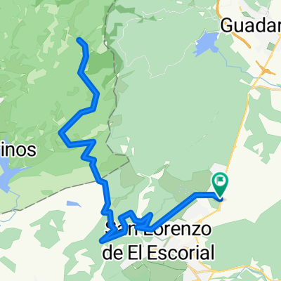
Climb up to La Penosilla, then ascend the dirt track towards the firebreak, descend towards the connection with the Valley of the Fallen, and when you reach the stone fence, return via the trial trail.
- -:--
- Duration
- 12.7 km
- Distance
- 481 m
- Ascent
- 480 m
- Descent
- ---
- Avg. speed
- ---
- Max. altitude

Continue with Bikemap
Use, edit, or download this cycling route
You would like to ride Valla de los Caídos (cuelgamuros) or customize it for your own trip? Here is what you can do with this Bikemap route:
Free features
- Save this route as favorite or in collections
- Copy & plan your own version of this route
- Sync your route with Garmin or Wahoo
Premium features
Free trial for 3 days, or one-time payment. More about Bikemap Premium.
- Navigate this route on iOS & Android
- Export a GPX / KML file of this route
- Create your custom printout (try it for free)
- Download this route for offline navigation
Discover more Premium features.
Get Bikemap PremiumFrom our community
Other popular routes starting in El Escorial
 Circular San Lorenzo-Jarosa-Peñota-Los Molinos
- Distance
- 42.7 km
- Ascent
- 731 m
- Descent
- 730 m
- Location
- El Escorial, Madrid, Spain
 Estación El Escorial - Abantos
- Distance
- 36.7 km
- Ascent
- 959 m
- Descent
- 959 m
- Location
- El Escorial, Madrid, Spain
 Ruta de los bunkers
- Distance
- 36.3 km
- Ascent
- 562 m
- Descent
- 559 m
- Location
- El Escorial, Madrid, Spain
 Vuelta a los Arroyos subida final a Penosilla
- Distance
- 39.8 km
- Ascent
- 547 m
- Descent
- 547 m
- Location
- El Escorial, Madrid, Spain
 Tomillar - Peñas Blancas (cruce)
- Distance
- 42.4 km
- Ascent
- 929 m
- Descent
- 929 m
- Location
- El Escorial, Madrid, Spain
 Ruta San Lorenzo-La Jarosa-La Mina-Peñas Blancas-San Lorenzo
- Distance
- 48.1 km
- Ascent
- 1,104 m
- Descent
- 1,104 m
- Location
- El Escorial, Madrid, Spain
 el escorial machotas
- Distance
- 17.4 km
- Ascent
- 648 m
- Descent
- 648 m
- Location
- El Escorial, Madrid, Spain
 El Escorial-Emb. de Valmayor-Valdemorillo
- Distance
- 46.8 km
- Ascent
- 402 m
- Descent
- 402 m
- Location
- El Escorial, Madrid, Spain
Open it in the app