

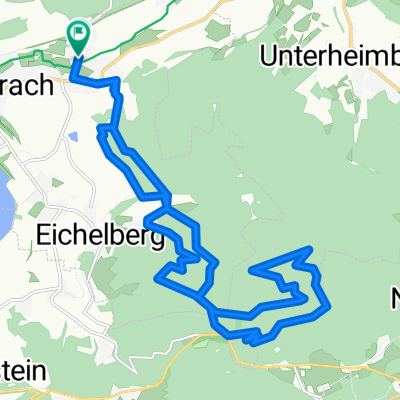
Bretzfeld-Meinhardt-Waldenburg-Öhringen-Bretzfeld
A cycling route starting in Bretzfeld, Baden-Wurttemberg, Germany.
Overview
About this route
The route is 99% asphalt, with only a short section before Waldenburg going through the forest, but those who wish can continue on the road.
- -:--
- Duration
- 60.2 km
- Distance
- 727 m
- Ascent
- 705 m
- Descent
- ---
- Avg. speed
- 505 m
- Max. altitude
Route quality
Waytypes & surfaces along the route
Waytypes
Road
22.9 km
(38 %)
Track
12.6 km
(21 %)
Surfaces
Paved
54.1 km
(90 %)
Unpaved
3 km
(5 %)
Asphalt
50.5 km
(84 %)
Paved (undefined)
3.6 km
(6 %)
Continue with Bikemap
Use, edit, or download this cycling route
You would like to ride Bretzfeld-Meinhardt-Waldenburg-Öhringen-Bretzfeld or customize it for your own trip? Here is what you can do with this Bikemap route:
Free features
- Save this route as favorite or in collections
- Copy & plan your own version of this route
- Sync your route with Garmin or Wahoo
Premium features
Free trial for 3 days, or one-time payment. More about Bikemap Premium.
- Navigate this route on iOS & Android
- Export a GPX / KML file of this route
- Create your custom printout (try it for free)
- Download this route for offline navigation
Discover more Premium features.
Get Bikemap PremiumFrom our community
Other popular routes starting in Bretzfeld
 vom Schwabbach nach Hölzern
- Distance
- 12.2 km
- Ascent
- 276 m
- Descent
- 274 m
- Location
- Bretzfeld, Baden-Wurttemberg, Germany
 kleine Übungsstrecke
- Distance
- 15.9 km
- Ascent
- 246 m
- Descent
- 247 m
- Location
- Bretzfeld, Baden-Wurttemberg, Germany
 Bretzfeld-Rottal-Runde
- Distance
- 59.4 km
- Ascent
- 470 m
- Descent
- 472 m
- Location
- Bretzfeld, Baden-Wurttemberg, Germany
 Bitzfelder Straße 10, Bretzfeld nach Bitzfelder Straße 10/1, Bretzfeld
- Distance
- 8.7 km
- Ascent
- 69 m
- Descent
- 125 m
- Location
- Bretzfeld, Baden-Wurttemberg, Germany
 Feierabendrunde
- Distance
- 21.3 km
- Ascent
- 555 m
- Descent
- 555 m
- Location
- Bretzfeld, Baden-Wurttemberg, Germany
 Route nach Hauptstraße 32, 74626 Bretzfeld
- Distance
- 40.4 km
- Ascent
- 530 m
- Descent
- 532 m
- Location
- Bretzfeld, Baden-Wurttemberg, Germany
 Scheppach-Wald-Breitenauer-Tour
- Distance
- 28.3 km
- Ascent
- 346 m
- Descent
- 346 m
- Location
- Bretzfeld, Baden-Wurttemberg, Germany
 Scheppach-Kocher-Neckar-Tour
- Distance
- 66.9 km
- Ascent
- 417 m
- Descent
- 426 m
- Location
- Bretzfeld, Baden-Wurttemberg, Germany
Open it in the app