Kampinos na sobotÄ™
A cycling route starting in Grodzisk Mazowiecki, Masovian Voivodeship, Poland.
Overview
About this route
- -:--
- Duration
- 88.7 km
- Distance
- 85 m
- Ascent
- 85 m
- Descent
- ---
- Avg. speed
- ---
- Max. altitude
Route quality
Waytypes & surfaces along the route
Waytypes
Road
37.2 km
(42 %)
Quiet road
21.9 km
(25 %)
Surfaces
Paved
52.1 km
(59 %)
Unpaved
16.4 km
(19 %)
Asphalt
46.8 km
(53 %)
Ground
7.5 km
(8 %)
Continue with Bikemap
Use, edit, or download this cycling route
You would like to ride Kampinos na sobotÄ™ or customize it for your own trip? Here is what you can do with this Bikemap route:
Free features
- Save this route as favorite or in collections
- Copy & plan your own version of this route
- Split it into stages to create a multi-day tour
- Sync your route with Garmin or Wahoo
Premium features
Free trial for 3 days, or one-time payment. More about Bikemap Premium.
- Navigate this route on iOS & Android
- Export a GPX / KML file of this route
- Create your custom printout (try it for free)
- Download this route for offline navigation
Discover more Premium features.
Get Bikemap PremiumFrom our community
Other popular routes starting in Grodzisk Mazowiecki
- Nagrano na Apple Watch 30 maj o 18:36
- Distance
- 19.4 km
- Ascent
- 29 m
- Descent
- 26 m
- Location
- Grodzisk Mazowiecki, Masovian Voivodeship, Poland
- Majowy trip
- Distance
- 33.6 km
- Ascent
- 102 m
- Descent
- 99 m
- Location
- Grodzisk Mazowiecki, Masovian Voivodeship, Poland
- Jana Kilińskiego 3, Grodzisk Mazowiecki do Jana Kilińskiego 5, Grodzisk Mazowiecki
- Distance
- 31.8 km
- Ascent
- 144 m
- Descent
- 143 m
- Location
- Grodzisk Mazowiecki, Masovian Voivodeship, Poland
- Grodzisk-Radziejowice-Siestrzeń-Wólka Kosowska-Warszawa
- Distance
- 64.5 km
- Ascent
- 136 m
- Descent
- 133 m
- Location
- Grodzisk Mazowiecki, Masovian Voivodeship, Poland
- przez Mlochow
- Distance
- 38.5 km
- Ascent
- 79 m
- Descent
- 81 m
- Location
- Grodzisk Mazowiecki, Masovian Voivodeship, Poland
- Z Natolina do domu przez Ożarów
- Distance
- 25 km
- Ascent
- 27 m
- Descent
- 17 m
- Location
- Grodzisk Mazowiecki, Masovian Voivodeship, Poland
- park ojrzanow treking
- Distance
- 91.3 km
- Ascent
- 454 m
- Descent
- 453 m
- Location
- Grodzisk Mazowiecki, Masovian Voivodeship, Poland
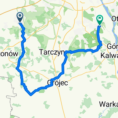
- Henryka Sienkiewicza do Henryka Sienkiewicza
- Distance
- 77.9 km
- Ascent
- 217 m
- Descent
- 250 m
- Location
- Grodzisk Mazowiecki, Masovian Voivodeship, Poland
Open it in the app