
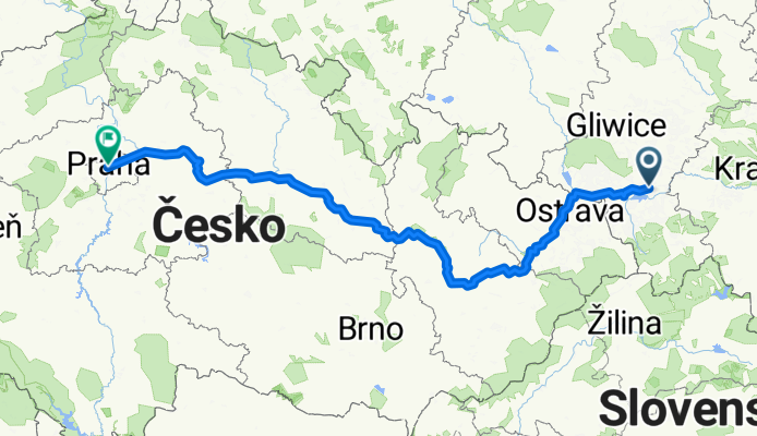
trip praga
A cycling route starting in Pszczyna, Silesian Voivodeship, Poland.
Overview
About this route
- -:--
- Duration
- 489.6 km
- Distance
- 733 m
- Ascent
- 789 m
- Descent
- ---
- Avg. speed
- ---
- Max. altitude

Route quality
Waytypes & surfaces along the route
Waytypes
Road
186.1 km
(38 %)
Quiet road
97.9 km
(20 %)
Surfaces
Paved
274.2 km
(56 %)
Unpaved
44.1 km
(9 %)
Asphalt
259.5 km
(53 %)
Gravel
19.6 km
(4 %)
Continue with Bikemap
Use, edit, or download this cycling route
You would like to ride trip praga or customize it for your own trip? Here is what you can do with this Bikemap route:
Free features
- Save this route as favorite or in collections
- Copy & plan your own version of this route
- Split it into stages to create a multi-day tour
- Sync your route with Garmin or Wahoo
Premium features
Free trial for 3 days, or one-time payment. More about Bikemap Premium.
- Navigate this route on iOS & Android
- Export a GPX / KML file of this route
- Create your custom printout (try it for free)
- Download this route for offline navigation
Discover more Premium features.
Get Bikemap PremiumFrom our community
Other popular routes starting in Pszczyna
 Trasa widokowa Goczałkowice
- Distance
- 22.3 km
- Ascent
- 1,199 m
- Descent
- 1,223 m
- Location
- Pszczyna, Silesian Voivodeship, Poland
 Pszczyna-Miedzna-Jawiszowice
- Distance
- 44.8 km
- Ascent
- 105 m
- Descent
- 104 m
- Location
- Pszczyna, Silesian Voivodeship, Poland
 Pszczyna-Jawiszowice
- Distance
- 48.8 km
- Ascent
- 134 m
- Descent
- 134 m
- Location
- Pszczyna, Silesian Voivodeship, Poland
 Pszczyna-Bielsko-Biała
- Distance
- 29.2 km
- Ascent
- 282 m
- Descent
- 192 m
- Location
- Pszczyna, Silesian Voivodeship, Poland
 Trasa z Łowiecka, Pszczyna
- Distance
- 18.5 km
- Ascent
- 62 m
- Descent
- 71 m
- Location
- Pszczyna, Silesian Voivodeship, Poland
 Pszczyna - Kobiór - Paprocany - Studzienice - Pszczyna 2 maja, 08:19
- Distance
- 42.8 km
- Ascent
- 145 m
- Descent
- 146 m
- Location
- Pszczyna, Silesian Voivodeship, Poland
 Pszczyna-Skoczów
- Distance
- 28.3 km
- Ascent
- 134 m
- Descent
- 88 m
- Location
- Pszczyna, Silesian Voivodeship, Poland
 Pszczyna - dookoła jeziora Goczałkowickiego
- Distance
- 46.3 km
- Ascent
- 96 m
- Descent
- 96 m
- Location
- Pszczyna, Silesian Voivodeship, Poland
Open it in the app