
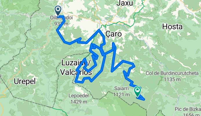
Saint-Etienne-de-Baïgorry - Errozate
A cycling route starting in Saint-Étienne-de-Baïgorry, Nouvelle-Aquitaine, France.
Overview
About this route
1xHC, 3x1eCat, 3x2eCat
- -:--
- Duration
- 101.5 km
- Distance
- 4,610 m
- Ascent
- 3,480 m
- Descent
- ---
- Avg. speed
- ---
- Max. altitude

Route quality
Waytypes & surfaces along the route
Waytypes
Quiet road
56.8 km
(56 %)
Road
32.5 km
(32 %)
Surfaces
Paved
24.4 km
(24 %)
Unpaved
16.2 km
(16 %)
Unpaved (undefined)
15.2 km
(15 %)
Paved (undefined)
13.2 km
(13 %)
Continue with Bikemap
Use, edit, or download this cycling route
You would like to ride Saint-Etienne-de-Baïgorry - Errozate or customize it for your own trip? Here is what you can do with this Bikemap route:
Free features
- Save this route as favorite or in collections
- Copy & plan your own version of this route
- Split it into stages to create a multi-day tour
- Sync your route with Garmin or Wahoo
Premium features
Free trial for 3 days, or one-time payment. More about Bikemap Premium.
- Navigate this route on iOS & Android
- Export a GPX / KML file of this route
- Create your custom printout (try it for free)
- Download this route for offline navigation
Discover more Premium features.
Get Bikemap PremiumFrom our community
Other popular routes starting in Saint-Étienne-de-Baïgorry
 Col d'Ispeguy // CBPF
- Distance
- 44.6 km
- Ascent
- 765 m
- Descent
- 770 m
- Location
- Saint-Étienne-de-Baïgorry, Nouvelle-Aquitaine, France
 Bicitour2016-3b
- Distance
- 91.8 km
- Ascent
- 803 m
- Descent
- 895 m
- Location
- Saint-Étienne-de-Baïgorry, Nouvelle-Aquitaine, France
 Bicitour2016-3
- Distance
- 84.9 km
- Ascent
- 1,781 m
- Descent
- 1,916 m
- Location
- Saint-Étienne-de-Baïgorry, Nouvelle-Aquitaine, France
 Jakobsweg Camino Francés Etappe 3
- Distance
- 99.5 km
- Ascent
- 1,697 m
- Descent
- 1,692 m
- Location
- Saint-Étienne-de-Baïgorry, Nouvelle-Aquitaine, France
 Saint-Etienne-de-Baïgorry - Errozate
- Distance
- 101.5 km
- Ascent
- 4,610 m
- Descent
- 3,480 m
- Location
- Saint-Étienne-de-Baïgorry, Nouvelle-Aquitaine, France
 Aldudes - Ehunzaroy
- Distance
- 149.2 km
- Ascent
- 4,078 m
- Descent
- 3,469 m
- Location
- Saint-Étienne-de-Baïgorry, Nouvelle-Aquitaine, France
 Urepel - Irouléguy
- Distance
- 42.3 km
- Ascent
- 1,241 m
- Descent
- 1,392 m
- Location
- Saint-Étienne-de-Baïgorry, Nouvelle-Aquitaine, France
 Urepel - Lindux - Ibañeta
- Distance
- 16.5 km
- Ascent
- 1,065 m
- Descent
- 371 m
- Location
- Saint-Étienne-de-Baïgorry, Nouvelle-Aquitaine, France
Open it in the app