

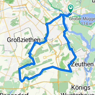
Köpenick - Rahnsdorf - Gosen - Schmöckwitz - Köpenick
A cycling route starting in Köpenick, State of Berlin, Germany.
Overview
About this route
- -:--
- Duration
- 34.1 km
- Distance
- 88 m
- Ascent
- 92 m
- Descent
- ---
- Avg. speed
- 51 m
- Max. altitude
Route quality
Waytypes & surfaces along the route
Waytypes
Quiet road
9.2 km
(27 %)
Pedestrian area
5.8 km
(17 %)
Surfaces
Paved
23.2 km
(68 %)
Unpaved
4.8 km
(14 %)
Asphalt
22.5 km
(66 %)
Gravel
3.4 km
(10 %)
Continue with Bikemap
Use, edit, or download this cycling route
You would like to ride Köpenick - Rahnsdorf - Gosen - Schmöckwitz - Köpenick or customize it for your own trip? Here is what you can do with this Bikemap route:
Free features
- Save this route as favorite or in collections
- Copy & plan your own version of this route
- Sync your route with Garmin or Wahoo
Premium features
Free trial for 3 days, or one-time payment. More about Bikemap Premium.
- Navigate this route on iOS & Android
- Export a GPX / KML file of this route
- Create your custom printout (try it for free)
- Download this route for offline navigation
Discover more Premium features.
Get Bikemap PremiumFrom our community
Other popular routes starting in Köpenick
 am müggelsee
- Distance
- 20.6 km
- Ascent
- 125 m
- Descent
- 123 m
- Location
- Köpenick, State of Berlin, Germany
 Herzfelde-Kienbaum-Spreeau-Erkner
- Distance
- 73.1 km
- Ascent
- 177 m
- Descent
- 172 m
- Location
- Köpenick, State of Berlin, Germany
 Köpenick - Schulzendorf - Wassmannsdorf - Köpenick
- Distance
- 53.2 km
- Ascent
- 70 m
- Descent
- 74 m
- Location
- Köpenick, State of Berlin, Germany
 Köppenick-Erkner-Wernsdorf-Grünau-Köpenick
- Distance
- 36.5 km
- Ascent
- 78 m
- Descent
- 80 m
- Location
- Köpenick, State of Berlin, Germany
 Köpenick-Burig-Mönchswinkel-Erkner-Südseite Müggelsee-Köpenick
- Distance
- 61.7 km
- Ascent
- 200 m
- Descent
- 196 m
- Location
- Köpenick, State of Berlin, Germany
 Gosen-Hangelsberg-Kienbaum-Erkner
- Distance
- 64.2 km
- Ascent
- 118 m
- Descent
- 120 m
- Location
- Köpenick, State of Berlin, Germany
 Müggelseerundtour
- Distance
- 28.4 km
- Ascent
- 59 m
- Descent
- 57 m
- Location
- Köpenick, State of Berlin, Germany
 gemütliche Tour am Langen See, Große Krampe, Müggelheim, Müggelsee CLONED FROM ROUTE 180167
- Distance
- 23.1 km
- Ascent
- 66 m
- Descent
- 66 m
- Location
- Köpenick, State of Berlin, Germany
Open it in the app