

Chablais d'Enfer Aulp-dessus
A cycling route starting in Monthey, Valais, Switzerland.
Overview
About this route
Giettes-Morgins-Corbier-Joux Verte-Joux Plane-Ramaz-Encrenaz-Corbier-Morgins
- -:--
- Duration
- 244.4 km
- Distance
- 5,048 m
- Ascent
- 5,048 m
- Descent
- ---
- Avg. speed
- ---
- Max. altitude

Route quality
Waytypes & surfaces along the route
Waytypes
Road
114.9 km
(47 %)
Quiet road
26.9 km
(11 %)
Surfaces
Paved
158.9 km
(65 %)
Unpaved
2.4 km
(1 %)
Asphalt
156.4 km
(64 %)
Concrete
2.4 km
(1 %)
Continue with Bikemap
Use, edit, or download this cycling route
You would like to ride Chablais d'Enfer Aulp-dessus or customize it for your own trip? Here is what you can do with this Bikemap route:
Free features
- Save this route as favorite or in collections
- Copy & plan your own version of this route
- Split it into stages to create a multi-day tour
- Sync your route with Garmin or Wahoo
Premium features
Free trial for 3 days, or one-time payment. More about Bikemap Premium.
- Navigate this route on iOS & Android
- Export a GPX / KML file of this route
- Create your custom printout (try it for free)
- Download this route for offline navigation
Discover more Premium features.
Get Bikemap PremiumFrom our community
Other popular routes starting in Monthey
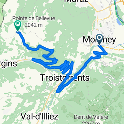
 Gravel de Monthey autour de la pointe Bellevue
- Distance
- 64.2 km
- Ascent
- 1,926 m
- Descent
- 1,925 m
- Location
- Monthey, Valais, Switzerland
 Recovered Route
- Distance
- 6.4 km
- Ascent
- 55 m
- Descent
- 9 m
- Location
- Monthey, Valais, Switzerland
 Col de Portes de Culet– Cols mythiques
- Distance
- 23.3 km
- Ascent
- 1,439 m
- Descent
- 80 m
- Location
- Monthey, Valais, Switzerland
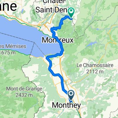 Monthey - Blonay
- Distance
- 44.2 km
- Ascent
- 1,222 m
- Descent
- 334 m
- Location
- Monthey, Valais, Switzerland
 Chablais d'Enfer Aulp-dessus
- Distance
- 244.4 km
- Ascent
- 5,048 m
- Descent
- 5,048 m
- Location
- Monthey, Valais, Switzerland
 Semaine 2
- Distance
- 40.7 km
- Ascent
- 460 m
- Descent
- 458 m
- Location
- Monthey, Valais, Switzerland
 Boucle Monthey-Bouveret
- Distance
- 45.6 km
- Ascent
- 278 m
- Descent
- 278 m
- Location
- Monthey, Valais, Switzerland
 My Tour
- Distance
- 28.6 km
- Ascent
- 76 m
- Descent
- 93 m
- Location
- Monthey, Valais, Switzerland
Open it in the app