

Bahn-Radweg-Lobberich-Schänzchen-Vieren
A cycling route starting in Nettetal, North Rhine-Westphalia, Germany.
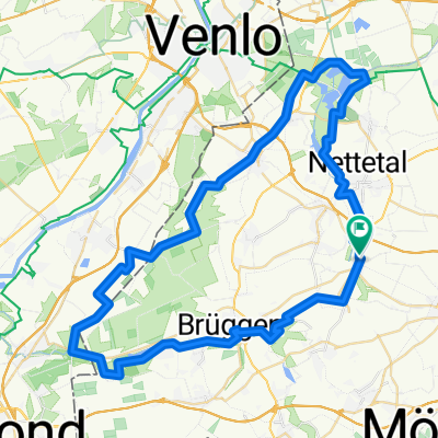
Overview
About this route
2 Teil - Rückfahrt vom Hotel "zum Schänzchen nach Viersen.
- -:--
- Duration
- 54.9 km
- Distance
- 107 m
- Ascent
- 124 m
- Descent
- ---
- Avg. speed
- ---
- Max. altitude

Route quality
Waytypes & surfaces along the route
Waytypes
Track
16.5 km
(30 %)
Quiet road
15.3 km
(28 %)
Surfaces
Paved
27.7 km
(50 %)
Unpaved
8.3 km
(15 %)
Asphalt
24.9 km
(45 %)
Gravel
5.6 km
(10 %)
Route highlights
Points of interest along the route
Point of interest after 5 km
Hotel zum Schänzchen
Continue with Bikemap
Use, edit, or download this cycling route
You would like to ride Bahn-Radweg-Lobberich-Schänzchen-Vieren or customize it for your own trip? Here is what you can do with this Bikemap route:
Free features
- Save this route as favorite or in collections
- Copy & plan your own version of this route
- Sync your route with Garmin or Wahoo
Premium features
Free trial for 3 days, or one-time payment. More about Bikemap Premium.
- Navigate this route on iOS & Android
- Export a GPX / KML file of this route
- Create your custom printout (try it for free)
- Download this route for offline navigation
Discover more Premium features.
Get Bikemap PremiumFrom our community
Other popular routes starting in Nettetal
 Heide-Seen Tour (Nettetal)
- Distance
- 59.3 km
- Ascent
- 106 m
- Descent
- 106 m
- Location
- Nettetal, North Rhine-Westphalia, Germany
 Deel 02 Ldam - Wenen: Route van Venlo naar Mamedy 20150406
- Distance
- 163.2 km
- Ascent
- 119 m
- Descent
- 104 m
- Location
- Nettetal, North Rhine-Westphalia, Germany
 Nettet. De Witt Gasth Galgenvenn
- Distance
- 13.7 km
- Ascent
- 48 m
- Descent
- 36 m
- Location
- Nettetal, North Rhine-Westphalia, Germany
 Schaag - Hariksee - Heidweiher - Schaag
- Distance
- 20.7 km
- Ascent
- 82 m
- Descent
- 83 m
- Location
- Nettetal, North Rhine-Westphalia, Germany
 Schwalm-Nette
- Distance
- 46.3 km
- Ascent
- 57 m
- Descent
- 58 m
- Location
- Nettetal, North Rhine-Westphalia, Germany
 „N“, die Nettetal-Runde, gegen Uhrzeiger
- Distance
- 30.2 km
- Ascent
- 111 m
- Descent
- 111 m
- Location
- Nettetal, North Rhine-Westphalia, Germany
 GL`s Seen-MTB-Strecke
- Distance
- 33.1 km
- Ascent
- 124 m
- Descent
- 124 m
- Location
- Nettetal, North Rhine-Westphalia, Germany
 ADFC KR TdM 6-2009
- Distance
- 36.7 km
- Ascent
- 73 m
- Descent
- 76 m
- Location
- Nettetal, North Rhine-Westphalia, Germany
Open it in the app