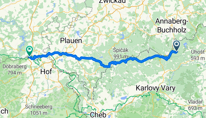
DD-TÜ 02 Erzgebirge - Vogtland
A cycling route starting in Kovářská, Ústecký kraj, Czechia.
Overview
About this route
.
- -:--
- Duration
- 124.4 km
- Distance
- 1,420 m
- Ascent
- 1,748 m
- Descent
- ---
- Avg. speed
- ---
- Max. altitude
Route quality
Waytypes & surfaces along the route
Waytypes
Road
59.7 km
(48 %)
Track
13.7 km
(11 %)
Surfaces
Paved
84.6 km
(68 %)
Unpaved
6.2 km
(5 %)
Asphalt
75.9 km
(61 %)
Paved (undefined)
7.5 km
(6 %)
Continue with Bikemap
Use, edit, or download this cycling route
You would like to ride DD-TÜ 02 Erzgebirge - Vogtland or customize it for your own trip? Here is what you can do with this Bikemap route:
Free features
- Save this route as favorite or in collections
- Copy & plan your own version of this route
- Split it into stages to create a multi-day tour
- Sync your route with Garmin or Wahoo
Premium features
Free trial for 3 days, or one-time payment. More about Bikemap Premium.
- Navigate this route on iOS & Android
- Export a GPX / KML file of this route
- Create your custom printout (try it for free)
- Download this route for offline navigation
Discover more Premium features.
Get Bikemap PremiumFrom our community
Other popular routes starting in Kovářská
- Z Kovářské do Abertam
- Distance
- 28.1 km
- Ascent
- 479 m
- Descent
- 427 m
- Location
- Kovářská, Ústecký kraj, Czechia
- Krušnohorské bezvětří
- Distance
- 46.3 km
- Ascent
- 661 m
- Descent
- 662 m
- Location
- Kovářská, Ústecký kraj, Czechia
- Oberwiesenthal - Keilberg - Fichtelberg - Oberwiesenthal
- Distance
- 15.3 km
- Ascent
- 576 m
- Descent
- 576 m
- Location
- Kovářská, Ústecký kraj, Czechia
- Krušnohorské bezvětří
- Distance
- 46.3 km
- Ascent
- 669 m
- Descent
- 669 m
- Location
- Kovářská, Ústecký kraj, Czechia
- Z Měděnce na Mědník, Střední Špičák a Jelení horu
- Distance
- 61.1 km
- Ascent
- 566 m
- Descent
- 1,046 m
- Location
- Kovářská, Ústecký kraj, Czechia
- #03-03 Měděnec (deutsch Kupferberg) - Wolkenstein
- Distance
- 38.1 km
- Ascent
- 302 m
- Descent
- 755 m
- Location
- Kovářská, Ústecký kraj, Czechia
- talsperre kupferberg bis Sebastiansberg
- Distance
- 13.7 km
- Ascent
- 181 m
- Descent
- 150 m
- Location
- Kovářská, Ústecký kraj, Czechia
- Údolím Přísečnice za doprovodu párovky
- Distance
- 55.4 km
- Ascent
- 461 m
- Descent
- 939 m
- Location
- Kovářská, Ústecký kraj, Czechia
Open it in the app