

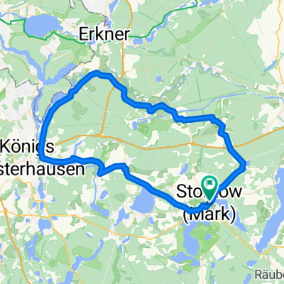
Rund um den Storkower See
A cycling route starting in Storkow, Brandenburg, Germany.
Overview
About this route
The tour began with our Bimobil in Storkow at the accessible toilet. However, the recording of the route to Wolfswinkel did not work out, so it was traced later. The route was good, a firm path, partly a little-used road up to Wendisch-Rietz. For the return, we wanted to ride a section of the "Didi-Senft" route, which is signposted as the Teufelstour. Unfortunately, this led into the forest and then to a planked path, signposted here as a footpath, which was not passable for us. We went back and then continued on other forest paths, which are certainly easy to ride with a normal bicycle. However, with the Bimobil, one needs wider paths; the ride was very arduous. This lack of route description was reported to the tourism office.
In Storkow, we strengthened ourselves in Netti's pantry.
- -:--
- Duration
- 19.7 km
- Distance
- 70 m
- Ascent
- 69 m
- Descent
- ---
- Avg. speed
- ---
- Max. altitude

Route photos

Route quality
Waytypes & surfaces along the route
Waytypes
Quiet road
6.9 km
(35 %)
Road
3.4 km
(17 %)
Surfaces
Paved
12.4 km
(63 %)
Unpaved
4.1 km
(21 %)
Asphalt
11.8 km
(60 %)
Ground
3.7 km
(19 %)
Continue with Bikemap
Use, edit, or download this cycling route
You would like to ride Rund um den Storkower See or customize it for your own trip? Here is what you can do with this Bikemap route:
Free features
- Save this route as favorite or in collections
- Copy & plan your own version of this route
- Sync your route with Garmin or Wahoo
Premium features
Free trial for 3 days, or one-time payment. More about Bikemap Premium.
- Navigate this route on iOS & Android
- Export a GPX / KML file of this route
- Create your custom printout (try it for free)
- Download this route for offline navigation
Discover more Premium features.
Get Bikemap PremiumFrom our community
Other popular routes starting in Storkow
 Schmausi Storkow 02
- Distance
- 68.3 km
- Ascent
- 115 m
- Descent
- 116 m
- Location
- Storkow, Brandenburg, Germany
 Storkow - Treidelweg
- Distance
- 15.5 km
- Ascent
- 31 m
- Descent
- 28 m
- Location
- Storkow, Brandenburg, Germany
 04_3-Seen-Tour_49_km
- Distance
- 48.4 km
- Ascent
- 243 m
- Descent
- 242 m
- Location
- Storkow, Brandenburg, Germany
 Karlsluster Straße nach Karlsluster Straße
- Distance
- 45.2 km
- Ascent
- 229 m
- Descent
- 229 m
- Location
- Storkow, Brandenburg, Germany
 U 18 4 große Rundfahrt
- Distance
- 44.6 km
- Ascent
- 66 m
- Descent
- 65 m
- Location
- Storkow, Brandenburg, Germany
 20151005_094804.gpx
- Distance
- 61.7 km
- Ascent
- 111 m
- Descent
- 118 m
- Location
- Storkow, Brandenburg, Germany
 Trip 2022-02-23
- Distance
- 33.5 km
- Ascent
- 121 m
- Descent
- 120 m
- Location
- Storkow, Brandenburg, Germany
 Im Reich der Fischadler (adfc Familientour)
- Distance
- 26.1 km
- Ascent
- 79 m
- Descent
- 79 m
- Location
- Storkow, Brandenburg, Germany
Open it in the app